Flash Flood Warning: What It Means, Why It Matters, and How to Stay Safe
Understanding the Urgency Behind Flash Flood Alerts
A flash flood warning is one of the most urgent weather alerts issued by meteorological authorities. Unlike general flood advisories, it signals that flooding is either already happening or will begin imminently—often within minutes or hours. These warnings are typically triggered by intense rainfall, rapidly rising water levels, or thunderstorms that overwhelm natural and urban drainage systems.
- Understanding the Urgency Behind Flash Flood Alerts
- A Rapidly Developing Weather Threat
- When Rainfall Becomes Dangerous
- The Real-World Impact of Flash Flooding
- Why Flash Flood Warnings Are Increasingly Common
- Safety Measures: What You Should Do Immediately
- What Comes Next?
- Conclusion: A Warning That Demands Immediate Action
On April 27, 2026, multiple flash flood warnings were issued across parts of Missouri and Kansas as severe weather systems unleashed heavy rainfall. The alerts, issued by the National Weather Service (NWS), highlighted a growing threat that quickly escalated from rainfall to dangerous flooding conditions affecting roads, communities, and infrastructure.
A Rapidly Developing Weather Threat
At 10:50 AM CDT, the National Weather Service in Springfield, Missouri, issued a flash flood warning for Northern Morgan County, citing Doppler radar data showing thunderstorms producing heavy rainfall. Up to 1 inch of rain had already fallen, with more expected shortly after.


The official alert stated:
- Hazard: Flash flooding caused by thunderstorms
- Source: Radar
- Impact: Flooding of small creeks, streams, urban areas, highways, streets, and underpasses
Communities including Stover, Syracuse, and Florence were identified as being at immediate risk.


Earlier that morning, another warning from the NWS in Pleasant Hill, Missouri, expanded the threat to multiple counties, including parts of Jackson, Clay, Lafayette, and Carroll counties. Rainfall totals in those areas ranged from 0.5 to 1.5 inches, with forecasts indicating an additional 0.5 to 2 inches possible.
When Rainfall Becomes Dangerous
Flash floods are defined not just by the amount of rainfall, but by the speed and intensity with which water accumulates. In the Kansas City region, the situation escalated dramatically, with an entire month’s worth of rain falling within just 24 hours.
Meteorologists reported that:
- Up to 4.5 inches of rain fell in a single day
- This matched or exceeded average rainfall totals for the entire month of April
- Saturated ground conditions prevented water absorption, accelerating runoff and flooding
The result was immediate and widespread disruption. Emergency services reported 11 water rescues, primarily involving drivers stranded after attempting to cross flooded roads.


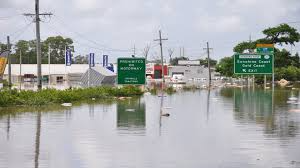
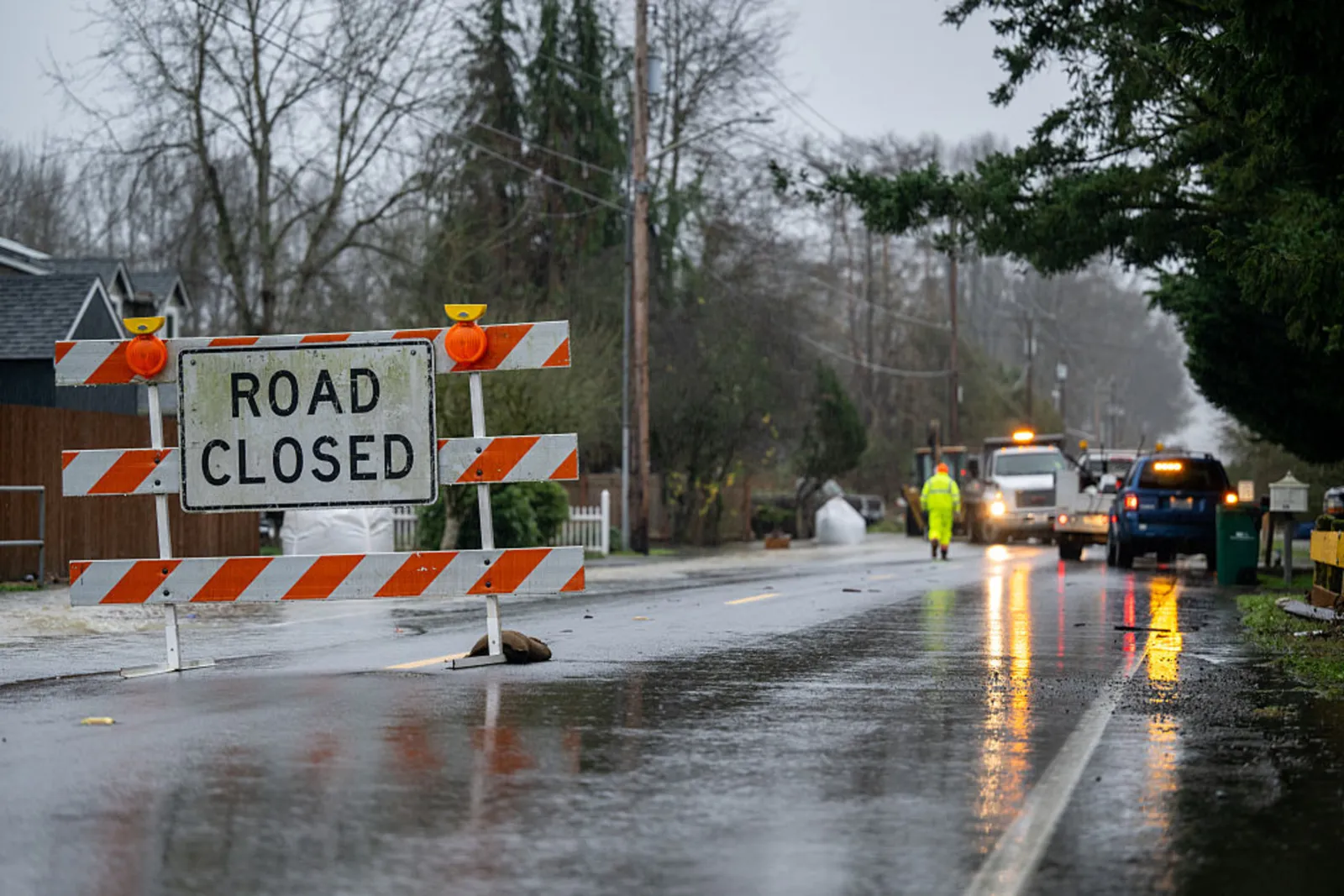
The Real-World Impact of Flash Flooding
Flash flooding poses a unique and dangerous threat due to its unpredictability and speed. The impacts observed during this weather event illustrate how quickly conditions can deteriorate:
1. Infrastructure and Transportation Disruptions
Floodwaters inundated:
- Major highways and interstates
- Streets and underpasses
- Low-water crossings
In Kansas, sections of Interstate 70 were affected, while in Missouri, urban centers like Independence and Blue Springs experienced flooding in critical roadways.
2. Urban and Rural Vulnerability
Both urban and rural areas faced risks:
- Urban areas suffered from overwhelmed drainage systems
- Rural regions saw creeks and streams rise rapidly
Low-lying areas and poor drainage zones were particularly susceptible.
3. Life-Threatening Conditions
Authorities consistently emphasized a key safety message:
“Turn around, don’t drown when encountering flooded roads. Most flood deaths occur in vehicles.”
This warning reflects a stark reality: even 12 inches of rushing water can sweep away a vehicle, and as little as 6 inches can knock a person off their feet.
Why Flash Flood Warnings Are Increasingly Common
Recent weather patterns suggest a growing frequency of intense rainfall events. Several contributing factors include:
- Slow-moving storm systems that release large volumes of rain over a short period
- Saturated ground conditions, reducing absorption capacity
- Urban expansion, which increases impermeable surfaces like concrete
These conditions combine to create ideal scenarios for flash flooding, even in areas that are not traditionally flood-prone.
Safety Measures: What You Should Do Immediately
When a flash flood warning is issued, time is critical. Authorities recommend the following actions:
Move to Safety
- Seek higher ground immediately if you are in a flood-prone area
- Avoid basements or low-lying rooms
Avoid Floodwaters
- Never walk, swim, or drive through floodwaters
- Floodwater may be contaminated or electrically charged
Follow Evacuation Orders
- If instructed to evacuate, do so without delay
- Secure your home and disconnect utilities if time allows
Driving Precautions
- Avoid flooded roads entirely
- Reduce speed in heavy rain to prevent hydroplaning
- Maintain safe distance from large vehicles that reduce visibility
What Comes Next?
While flash flood warnings are often short-lived, the broader weather system can continue to pose risks. Meteorologists noted that:
- Additional rainfall of up to 3 inches was possible in affected areas
- Flood watches remained in place for wider regions
- Severe thunderstorms and tornado risks continued to track eastward
Looking ahead, forecasts suggested a potential shift toward below-average precipitation over the next 6 to 14 days, offering some relief—but only after the immediate danger subsides.
Conclusion: A Warning That Demands Immediate Action
Flash flood warnings are not routine weather alerts—they are critical, time-sensitive signals of imminent danger. The events of April 27, 2026, demonstrate how quickly heavy rainfall can escalate into life-threatening flooding, affecting millions of people across multiple states.
From stranded vehicles to emergency rescues and widespread road closures, the consequences are immediate and severe. Understanding the meaning of these warnings—and responding quickly—can be the difference between safety and disaster.
As extreme weather events become more frequent, preparedness and awareness remain the most effective tools for reducing risk.