Cape Town Weather Warning Escalates as South Africa Faces Severe Storm Crisis
Cape Town and large parts of the Western Cape are bracing for one of the most dangerous weather events in years after authorities issued multiple high-level warnings for disruptive rainfall, damaging winds, coastal hazards, and possible flooding. The deteriorating conditions have become so severe that the South African government has officially classified the broader weather emergency affecting several provinces as a national disaster.
- National Disaster Declaration Raises Alarm
- Orange Level 8 Warning Issued for Cape Town Region
- Heavy Rainfall Expected Through Tuesday
- Coastal Areas Face Dangerous Winds and Waves
- Damaging Winds Threaten Transport and Power Infrastructure
- Snowfall and Extreme Cold Add to Concerns
- Cape Town Disaster Teams Activated
- Why This Weather System Is So Dangerous
- Economic and Social Impact Could Be Significant
- Forecast Shows Improvement Later in the Week
- A Critical Test for Emergency Preparedness
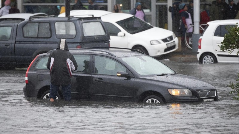
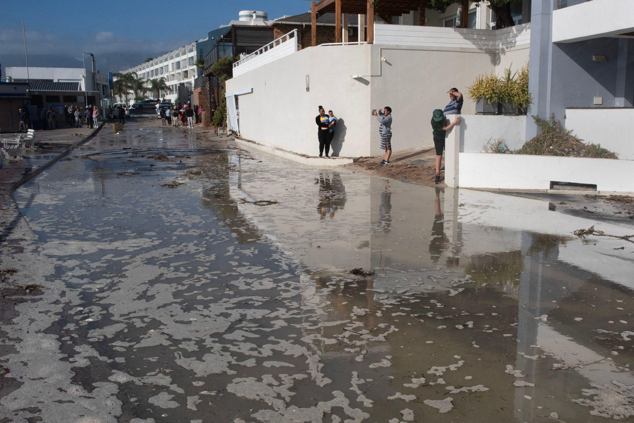
The latest forecasts point to days of relentless rain, gale-force winds, rough seas, and dangerous flooding risks stretching across Cape Town, the Cape Winelands, the Overberg, and other surrounding regions. Officials are warning residents to avoid unnecessary travel, stay away from rivers and coastal areas, and prepare for worsening conditions through Tuesday.
The warnings come after devastating storms already swept through several provinces, leaving destruction, displacement, and loss of life in their wake.


National Disaster Declaration Raises Alarm
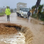
Government authorities confirmed that severe weather conditions affecting the Western Cape, Eastern Cape, Northern Cape, Free State, North West, and Mpumalanga have now been classified as a national disaster. The declaration follows widespread flooding, infrastructure destruction, and emergency rescue operations across multiple regions.
The disaster classification is intended to unlock emergency relief funding and accelerate rehabilitation and recovery efforts.


Officials reported that a 12-year-old girl died after being swept away by floodwaters in the North West province. In the Eastern Cape, more than 40 people trapped by flooding in Kouga had to be rescued. Authorities on the Garden Route described the destruction there as the worst disaster experienced in three decades.
At the same time, meteorologists warned that the Western Cape could face even heavier rainfall in the coming days.
Orange Level 8 Warning Issued for Cape Town Region
The South African Weather Service (SAWS) issued an Orange Level 8 weather warning for disruptive rainfall across parts of the Western Cape, including areas connected to Cape Town. This is among the highest warning categories issued by the agency and signals the likelihood of significant impacts to communities and infrastructure.
The warning covers:


- The mountainous regions of Drakenstein
- Stellenbosch
- Western parts of Theewaterskloof
- Breede Valley
- Witzenberg
- The City of Cape Town
According to SAWS, the storm system could trigger:
- Flooding of roads and bridges
- Flooding in formal and informal settlements
- Mudslides and rockfalls
- Major traffic disruptions
- Fast-flowing rivers creating danger to life
- Communities becoming temporarily inaccessible
The weather service also warned that saturated ground conditions could increase the risk of infrastructure collapse and prolonged transport disruptions.
Heavy Rainfall Expected Through Tuesday
Forecasts from multiple weather agencies show prolonged rainfall continuing for several days over Cape Town and surrounding districts.
Weather projections indicated:
- Rain probabilities reaching 95% or higher during several periods
- Continuous heavy rain from Sunday through Tuesday
- Wind gusts exceeding 65–70 kph
- Temperatures dropping sharply with cold, wet conditions
Forecasters also warned that intense downpours may repeatedly hit the same areas, increasing the risk of flash flooding and overflowing waterways.
The South African Weather Service forecast around 30 mm of rainfall for Cape Town alone, with significantly higher totals possible in mountainous regions.
Coastal Areas Face Dangerous Winds and Waves
The severe weather event is not limited to inland flooding.
Authorities also issued Orange Level 6 warnings for damaging winds and waves along coastal areas between Lambert’s Bay and Cannon Rocks. Maritime authorities warned that sea conditions could become extremely dangerous, particularly for fishing vessels, cargo ships, and recreational marine activities.
Potential coastal impacts include:
- Damage to coastal infrastructure
- Dangerous navigation conditions
- Large waves crashing onto roads and walkways
- Harbour disruptions
- Anchoring failures for larger vessels
- Coastal erosion
- Beachfront activity disruptions
Warnings were issued for numerous coastal zones including:
- Table Bay
- Cape Point
- Hermanus
- Mossel Bay
- Saldanha Bay
- Plettenberg Bay
- Knysna
Officials specifically cautioned rock anglers and coastal visitors against venturing near shorelines during the storm period because of the risk of being swept away by waves.
Damaging Winds Threaten Transport and Power Infrastructure
Strong interior winds are expected to create additional hazards across the Western Cape and parts of the Eastern Cape.
An Orange Level 5 warning for damaging winds highlighted risks including:
- Falling trees
- Power interruptions
- Damage to informal settlements
- Dangerous driving conditions
- High risks for trucks and high-sided vehicles
- Route closures
Wind damage warnings extend across multiple municipalities including:
- Cape Town
- Paarl
- Worcester
- Stellenbosch
- Hermanus
- Ceres
- Malmesbury
- Sutherland
Forecasts suggested gusts could exceed 50 mph in exposed areas during the peak of the storm.
Snowfall and Extreme Cold Add to Concerns
As the cold front pushes inland, weather officials also warned about snowfall and freezing conditions in higher-altitude areas.
Yellow Level 2 warnings for disruptive snowfall were issued for:
- Karoo Hoogland municipality
- Parts of the Cape Winelands
- Northern parts of the Eastern Cape
Authorities warned that icy roads could force mountain pass closures and create dangerous travel conditions. Farmers were also advised that livestock losses could occur due to extreme cold and exposure.
Additional weather advisories warned of hypothermia risks and agricultural impacts in regions such as:
- Worcester
- Paarl
- Ceres
- Robertson
- Calvinia
- Sutherland
Cape Town Disaster Teams Activated
The Western Cape government confirmed that emergency coordination systems have been fully activated in response to the escalating threat.
The Provincial Disaster Management Centre stated that:
“The Provincial Disaster Management Centre has activated coordination mechanisms across all districts and in the City of Cape Town, with all disaster management centres placed on high alert.”
Emergency officials are monitoring flood-prone communities, vulnerable settlements, transport corridors, and coastal infrastructure.
Residents have been urged to:
- Monitor official weather updates
- Avoid unnecessary travel
- Stay away from rivers and flooded roads
- Secure loose outdoor objects
- Prepare emergency kits
- Protect pets and livestock
- Avoid recreational sea activities
Authorities repeatedly emphasized that residents should never attempt to cross flooded roads or swollen rivers.
Why This Weather System Is So Dangerous
Meteorologists say the current storm system combines several high-risk weather elements occurring simultaneously:
- Prolonged rainfall over saturated ground
- Gale-force coastal winds
- Rough ocean conditions
- Cold air intrusion
- Mountain runoff intensifying flood risks
The combination increases the likelihood of cascading impacts where flooding, power failures, transport disruptions, and infrastructure damage occur at the same time.
Weather experts noted that mountainous terrain surrounding Cape Town and the Cape Winelands can rapidly channel water into rivers and urban drainage systems, worsening flash flood conditions.
Economic and Social Impact Could Be Significant
The weather emergency could have far-reaching consequences beyond immediate safety concerns.
Potential impacts include:
Transport Disruptions
Flooded highways, damaged roads, and fallen trees may severely affect travel and freight movement across the Western Cape.
Agricultural Losses
Heavy rain, freezing temperatures, and snow threaten crops and livestock in farming regions already under pressure from volatile weather conditions.
Coastal Business Interruptions
Harbours, fisheries, tourism operators, and beachfront businesses could face temporary shutdowns because of dangerous marine conditions.
Infrastructure Damage
Floodwaters and mudslides may damage bridges, roads, rail networks, drainage systems, and power infrastructure.
Vulnerable Communities at Risk
Informal settlements remain particularly vulnerable to flooding, displacement, and storm damage.
Forecast Shows Improvement Later in the Week
Despite the severe conditions expected through Tuesday, forecasts suggest gradual improvement later in the week.
Weather models indicate:
- Rain easing by Wednesday
- Conditions turning partly cloudy midweek
- Sunshine returning from Thursday onward
- Temperatures slowly recovering toward the weekend
Cape Town is expected to see clearer and calmer weather by Friday and Saturday if forecast trends remain stable.
A Critical Test for Emergency Preparedness
The Cape Town weather warning situation has become one of South Africa’s most serious severe-weather events of 2026 so far. With multiple high-level alerts active simultaneously and a national disaster declaration already in place, the coming days will test emergency preparedness systems across the Western Cape.
Authorities continue urging residents not to underestimate the danger posed by floodwaters, gale-force winds, and coastal conditions. For many communities across Cape Town and surrounding regions, the priority over the next several days will be safety, preparedness, and resilience as the powerful storm system moves through the province.