Storm Cape Town: Western Cape Braces for Another Dangerous Weather System
Cape Town and large parts of South Africa’s Western Cape are once again facing the threat of severe weather as authorities issue fresh warnings over a powerful storm system expected to bring flooding, damaging winds, rough seas, and snowfall across multiple districts.
- Level 8 Warning Raises Alarm Across Cape Town
- Emergency Services on High Alert
- Strong Winds and Violent Seas Threaten Coastal Areas
- Snowfall Expected in Mountainous Regions
- Province Still Recovering From Earlier Storm Damage
- Public Urged to Prepare Immediately
- Climate and Infrastructure Pressures Under Scrutiny
- What Happens Next?
The latest alerts come just days after earlier storms caused widespread destruction across the province, shutting down schools, damaging infrastructure, displacing residents, and triggering emergency evacuations in flood-prone communities.

Level 8 Warning Raises Alarm Across Cape Town
The South African Weather Service (SAWS) escalated its weather alert to an Orange Level 8 warning for disruptive rainfall expected from Sunday, 10 May, through Tuesday, 12 May 2026. Authorities say the incoming cold front could produce some of the most severe weather conditions seen in the region this year.


The warning covers Cape Town, the Cape Winelands, Overberg, sections of the West Coast, and mountainous regions including Drakenstein, Stellenbosch, Breede Valley, Witzenberg, and parts of Theewaterskloof.
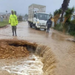
Officials warned that rainfall totals between 100mm and 200mm could fall in some areas, significantly increasing the risk of flooding, mudslides, overflowing rivers, and dangerous fast-flowing floodwaters.


Cape Town Mayor Geordin Hill-Lewis also warned residents that more than 150mm of rain could fall within 48 hours, leading to “significant disruption, flooding, fallen trees etc.”
Emergency Services on High Alert
Western Cape Premier Alan Winde confirmed that disaster response teams have already been activated as the province prepares for another round of extreme weather.
“The Provincial Disaster Management Centre has activated coordination mechanisms across all districts and in the City of Cape Town, with all disaster management centres placed on high alert ahead of the approaching system,” provincial authorities said.
Emergency officials are particularly concerned about:


- Flooding of roads, bridges, and low-lying communities
- Damage to coastal infrastructure
- Disruptions in formal and informal settlements
- Dangerous sea conditions
- Fallen trees and power interruptions
- Hazardous travel conditions
Charlotte Powell, spokesperson for Disaster Risk Management, said the elevated warning level indicates a “high likelihood of serious impacts” throughout affected areas.
Strong Winds and Violent Seas Threaten Coastal Areas
The storm is not only expected to bring torrential rainfall. SAWS also issued Orange Level 5 and Level 6 warnings for damaging winds and rough sea conditions stretching along the coastline between Lambert’s Bay and Plettenberg Bay.
Forecasters warned of gale-force winds, rapidly deteriorating sea conditions, and dangerous waves capable of damaging coastal infrastructure and threatening maritime navigation.
Interior districts may experience wind speeds between 50km/h and 70km/h, with authorities warning of:
- Falling trees
- Structural damage
- Power outages
- Dangerous driving conditions
- Route closures
Residents have been advised to secure loose outdoor objects and avoid unnecessary travel during the storm period.
Snowfall Expected in Mountainous Regions
Adding to the severe weather concerns, forecasters also issued a Yellow Level 2 warning for disruptive snowfall in parts of the Western Cape and Northern Cape.
Areas including the Karoo Hoogland municipality and parts of the Cape Winelands could experience icy roads, mountain pass closures, and sharp temperature drops.
Farmers were urged to relocate livestock and equipment to safer ground as freezing conditions threaten vulnerable animals and agricultural operations.
Province Still Recovering From Earlier Storm Damage
The renewed warnings arrive while many communities are still recovering from the devastating storms that battered the Western and Eastern Cape earlier in the week.
Floodwaters submerged roads, closed schools and clinics, and forced evacuations in vulnerable communities. One person reportedly died due to storm-related damage, while a 12-year-old child drowned after being swept away by floodwaters.
In the Gamtoos River region, overflowing dams and rivers triggered evacuations as authorities opened emergency shelters for displaced residents. The Kouga Dam overflowed, leaving downstream communities vulnerable to flooding.
The latest storm system is expected to place even greater strain on emergency services and already saturated infrastructure.
Public Urged to Prepare Immediately
Authorities across the Western Cape are urging residents to remain vigilant and closely follow official weather updates as conditions evolve.
The South African Weather Service advised residents to:
- Avoid crossing flooded roads and swollen rivers
- Stay away from coastal areas during severe sea conditions
- Prepare emergency kits with blankets, batteries, and flashlights
- Ensure pets and livestock have proper shelter
- Avoid unnecessary travel during periods of intense rainfall
- Monitor official communication channels for emergency updates
Community leaders and disaster management officials were also encouraged to activate contingency plans in vulnerable areas.
Climate and Infrastructure Pressures Under Scrutiny
The repeated severe weather events have reignited concerns about urban flooding preparedness, infrastructure resilience, and climate-related disaster risks in South Africa’s coastal provinces.
Cape Town’s combination of dense urban development, informal settlements in flood-prone areas, and aging drainage systems has made the city particularly vulnerable during periods of intense rainfall.
With weather systems becoming more frequent and severe, experts say investment in stormwater infrastructure, emergency response systems, and climate adaptation strategies will likely become increasingly important for municipalities across the Western Cape.
What Happens Next?
Meteorologists expect the storm system to remain active until at least Tuesday, 12 May 2026, with forecasts subject to change as the cold front develops further.
Authorities warned that warning levels may still be updated depending on rainfall intensity and wind conditions over the coming days.
For now, Cape Town residents are being urged to remain cautious, prepare for possible disruptions, and avoid taking unnecessary risks as another dangerous storm moves toward the city.