El Niño 2026: Why Scientists Are Watching the Pacific With Growing Concern
The Pacific Ocean is once again becoming the center of global climate attention.
After months of monitoring warming ocean waters, meteorologists and climate agencies across the world are warning that El Niño conditions could rapidly intensify during 2026 — potentially evolving into a rare “super El Niño” capable of reshaping weather patterns across continents. From drought risks in Southeast Asia to flooding concerns in East Africa and shifts in hurricane activity in the Atlantic, the phenomenon is already influencing climate forecasts for late 2026 and early 2027.
Scientists say the event may rival some of the strongest El Niño episodes ever recorded, including the devastating 1997–1998 and 2015–2016 events.


What Exactly Is El Niño?
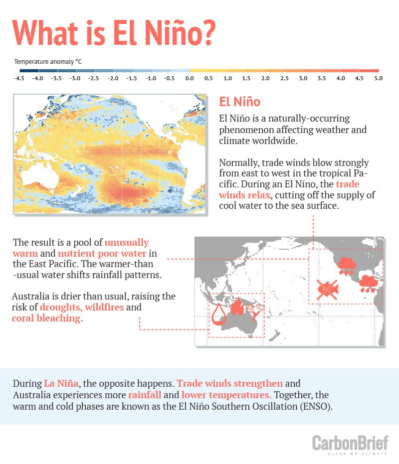
El Niño is a naturally occurring climate pattern linked to unusually warm sea surface temperatures in the central and eastern tropical Pacific Ocean. It forms part of a larger climate cycle known as the El Niño–Southern Oscillation (ENSO), which alternates between warm El Niño phases, cool La Niña phases, and neutral conditions.
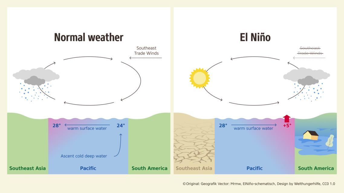
Under normal conditions, trade winds push warm surface water westward toward Asia and Australia, while cooler water rises near South America. During El Niño, those trade winds weaken or reverse, allowing warm water to spread eastward across the Pacific. The result is a massive redistribution of heat and atmospheric energy that alters rainfall, temperatures, jet streams, and storm systems worldwide.


El Niño events typically occur every two to seven years and can last between nine and twelve months.
Why 2026 Is Raising Alarm Bells
Climate models are increasingly pointing toward the rapid development of El Niño conditions by mid-2026. The World Meteorological Organization (WMO) has indicated high confidence that El Niño will emerge as Pacific Ocean temperatures continue warming quickly.
Several climate agencies and meteorological organizations now believe the event could strengthen significantly by late 2026:
- NOAA estimates roughly a 60 percent chance of El Niño forming between May and July 2026.
- Some forecasts place the probability of a “super El Niño” at around 25 percent.
- Sea surface temperatures in the Niño 3.4 region are already measuring 3–4°C above normal in some monitoring models.
- Climate scientists monitoring the Pacific say subsurface ocean temperatures are exceptionally warm, a common precursor to strong El Niño events.
The concern is not only about El Niño itself, but about how it combines with ongoing global warming. Scientists note that modern El Niño events now occur in an already warmer atmosphere and ocean system, amplifying extreme weather impacts.


What Makes a “Super El Niño”?
A “super El Niño” refers to exceptionally strong warming in the equatorial Pacific Ocean, usually when sea surface temperatures exceed 2°C above average.
The strongest events in modern history occurred in:
- 1982–1983
- 1997–1998
- 2015–2016
These episodes triggered catastrophic flooding, devastating droughts, coral bleaching, wildfires, agricultural disruptions, and record global temperatures.
The 1997–1998 El Niño alone caused billions of dollars in economic losses globally and reshaped weather systems for more than a year. Some experts now believe the developing 2026 system could rival or even exceed those historic events.
How El Niño Changes Global Weather
Because the Pacific Ocean covers roughly one-third of Earth’s surface, changes there ripple across the planet through atmospheric “teleconnections.”
United States
In the United States, El Niño typically shifts the jet stream southward and eastward, changing rainfall and storm patterns.
Potential impacts include:
- Wetter conditions across the southern United States
- Milder winters in parts of the East Coast
- Increased rainfall in California
- Reduced Atlantic hurricane activity
- Increased Pacific hurricane activity
- Cooler or less intense summer heat in some eastern states
Meteorologist Matthew Teare of the National Weather Service noted that El Niño often correlates with “a milder and wetter winter” along the East Coast, though strong snowstorms can still occur due to increased atmospheric moisture.
East Africa
East African nations such as Tanzania and Kenya are preparing for possible severe weather disruptions linked to the developing system. Forecasts warn that parts of the region could experience powerful storms, floods, droughts, and abnormal weather extremes between late 2026 and early 2027.
The Intergovernmental Authority on Development’s Climate Prediction and Application Center (ICPAC) has already convened virtual meetings to discuss preparedness strategies across the continent.
Regional climate centers are studying potential impacts on:
- Agriculture
- Water resources
- Energy systems
- Public health
- Livelihoods
- Disaster risk management
The feared comparison is the devastating 1997–1998 El Niño, which caused widespread flooding across East Africa.
Southeast Asia and Singapore
In Southeast Asia, the major concern is drought, heatwaves, haze pollution, and forest fires.
Singapore’s Minister for Sustainability and the Environment, Grace Fu, recently warned that a possible “Godzilla” El Niño could intensify regional forest fires and transboundary haze later in 2026.
Climate scientist Koh Tieh Yong said reduced rainfall could significantly lower water reservoir levels in both Singapore and Johor, potentially increasing reliance on desalination and recycled water systems.
Experts also fear:
- Prolonged drought
- Extreme heatwaves
- Expanded peatland fires
- Severe haze events
- Pressure on food production
The region still remembers the 2015 haze crisis, when smoke from Indonesian fires forced school closures in Singapore.
Climate Change Is Complicating the Picture
Scientists stress that El Niño itself is a natural climate cycle, not a direct product of climate change. However, global warming is amplifying its effects.
Warmer oceans contain more heat and moisture, increasing the likelihood of extreme rainfall, heatwaves, and marine heat stress.
Climate experts also note that strong El Niño events are often followed by sharp jumps in global average temperatures. After the 2015–2016 El Niño, global temperatures increased by roughly 0.2°C. Similar warming occurred following the 2023–2024 event.
Some forecasts now suggest that 2027 could become the hottest year ever recorded if the current El Niño intensifies further.
Threats to Oceans and Coral Reefs
Marine ecosystems may also face another major stress test.
The previous El Niño contributed to the fourth global mass coral bleaching event, affecting more than 80 percent of the world’s coral reefs.
During bleaching events, corals expel the algae living in their tissues due to heat stress, turning white and becoming vulnerable to death.
In Singapore, roughly 44 percent of surveyed coral colonies bleached during the 2024 marine heatwave.
Scientists are now racing to protect reefs by experimenting with heat-resistant coral species and microbial adaptation programs before another potential marine heatwave arrives.
Scientists Are Still Watching for Confirmation
Despite growing concern, forecasters caution that uncertainty remains.
Climate experts frequently mention the “spring predictability barrier,” a period during March through May when ENSO forecasts are historically less reliable.
According to Climate Impact Company, ocean warming is already clearly visible, but the atmosphere has not yet fully responded in a sustained way.
The organization noted:
“The equatorial oceanic warming is there but the atmospheric reflection lags.”
Meteorologists are closely monitoring several indicators, including:
- Trade wind strength
- Southern Oscillation Index (SOI)
- Subsurface Pacific warming
- Madden-Julian Oscillation patterns
If those atmospheric signals strengthen during late May and June, confidence in a major El Niño event could increase substantially.
A Global Climate Test Ahead
El Niño has long been considered one of Earth’s most powerful climate disruptors. NASA describes it as a “master weather-maker” because of its ability to reshape atmospheric circulation worldwide.
The developing 2026 event arrives at a time when the planet is already experiencing record ocean temperatures, accelerating climate extremes, and growing environmental stress.
For governments, farmers, emergency agencies, and climate scientists, the coming months may determine whether the world is heading toward another historic climate event — one capable of influencing everything from food prices and water supplies to hurricanes, wildfires, and global temperatures.
While modern forecasting tools provide better preparedness than in previous decades, experts warn that preparedness alone may not eliminate the risks of a rapidly intensifying super El Niño.