Flash Flood Risk Explained: Why Sudden Flooding Is Becoming More Dangerous
When Rain Turns Into a Rapid Threat
Flash flood risk is one of the most underestimated weather hazards—often developing in minutes, yet capable of causing widespread disruption, damage, and loss of life. Unlike slow-rising floods, flash floods emerge quickly, typically triggered by intense rainfall overwhelming drainage systems or saturating already stressed environments.
- When Rain Turns Into a Rapid Threat
- A Real-Time Case Study: Florida’s Rising Flood Threat
- What Drives Flash Flood Risk?
- A Double-Edged Sword: Relief and Risk
- The Hidden Dangers of Flash Flooding
- Local Impacts: What Communities Can Expect
- The Bigger Picture: A Growing Global Concern
- Looking Ahead: Why Preparedness Matters
- Conclusion: A Fast-Moving Hazard With Lasting Impact
Recent weather patterns across Florida illustrate how quickly these risks can escalate. A cold front sweeping through the region has brought multiple rounds of heavy showers and thunderstorms, increasing the likelihood of localized flooding, particularly in urban areas.
A Real-Time Case Study: Florida’s Rising Flood Threat
Meteorologists tracking conditions across the Gulf Coast and South Florida have highlighted a growing flash flood risk tied to persistent moisture and repeated storm activity. According to forecasts, the same cold front that moved through northern and central Florida is now stalling over the southern part of the state—creating conditions for prolonged rainfall.


The result is a Level 1 out of 4 flash flood threat, signaling a low but notable risk of flooding. Rainfall totals are expected to reach 1 to 2 inches, with isolated areas potentially receiving 3 to 4 inches in a short window—a key trigger for flash flooding.
Compounding the risk is a phenomenon known as “training storms,” where multiple storms repeatedly pass over the same area. This pattern significantly increases the chance of water accumulation, particularly in densely populated urban corridors like Miami and Fort Lauderdale.


What Drives Flash Flood Risk?
Flash floods occur when rainfall intensity exceeds the ability of the ground or drainage systems to absorb water. Several factors amplify this risk:
1. Intense, Short-Duration Rainfall
Heavy downpours—like those expected in Florida—can deposit inches of rain within hours. When this happens faster than water can drain, flooding becomes inevitable.
2. Urban Infrastructure Limitations
Cities are particularly vulnerable. Pavement and concrete prevent water from soaking into the ground, leading to rapid surface runoff.
3. Repeated Storm Activity
When storms follow the same path—“training”—water builds up quickly, increasing the likelihood of flash flooding.


4. Pre-Existing Conditions
Ironically, both drought and saturated soil can contribute. In Florida’s case, prolonged dry conditions have hardened the ground, reducing its ability to absorb sudden rainfall.
A Double-Edged Sword: Relief and Risk
While flash flood risk is a serious concern, the same rainfall can also bring benefits. Large portions of South Florida have been experiencing extreme drought, along with heightened wildfire danger.
The incoming rain is expected to:
- Provide substantial relief to parched vegetation
- Help reduce wildfire risk
- Replenish moisture levels across the region
However, this benefit comes with trade-offs. Urban areas may experience temporary ponding, where water accumulates on streets and low-lying areas, disrupting transportation and daily life.
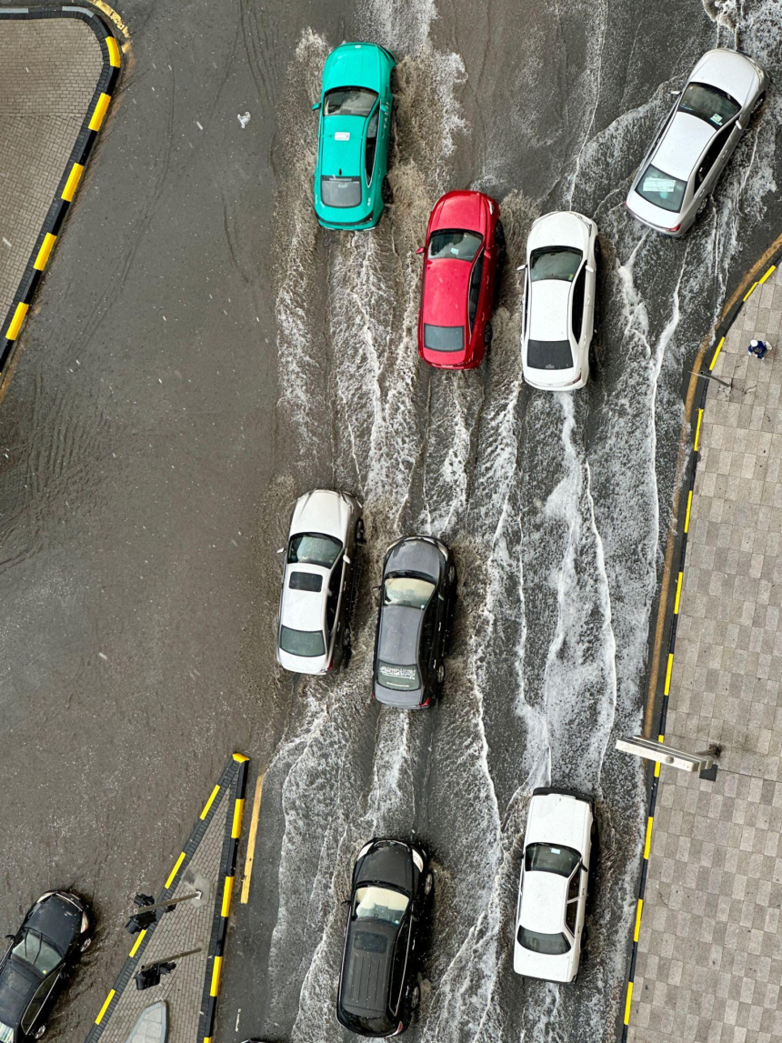
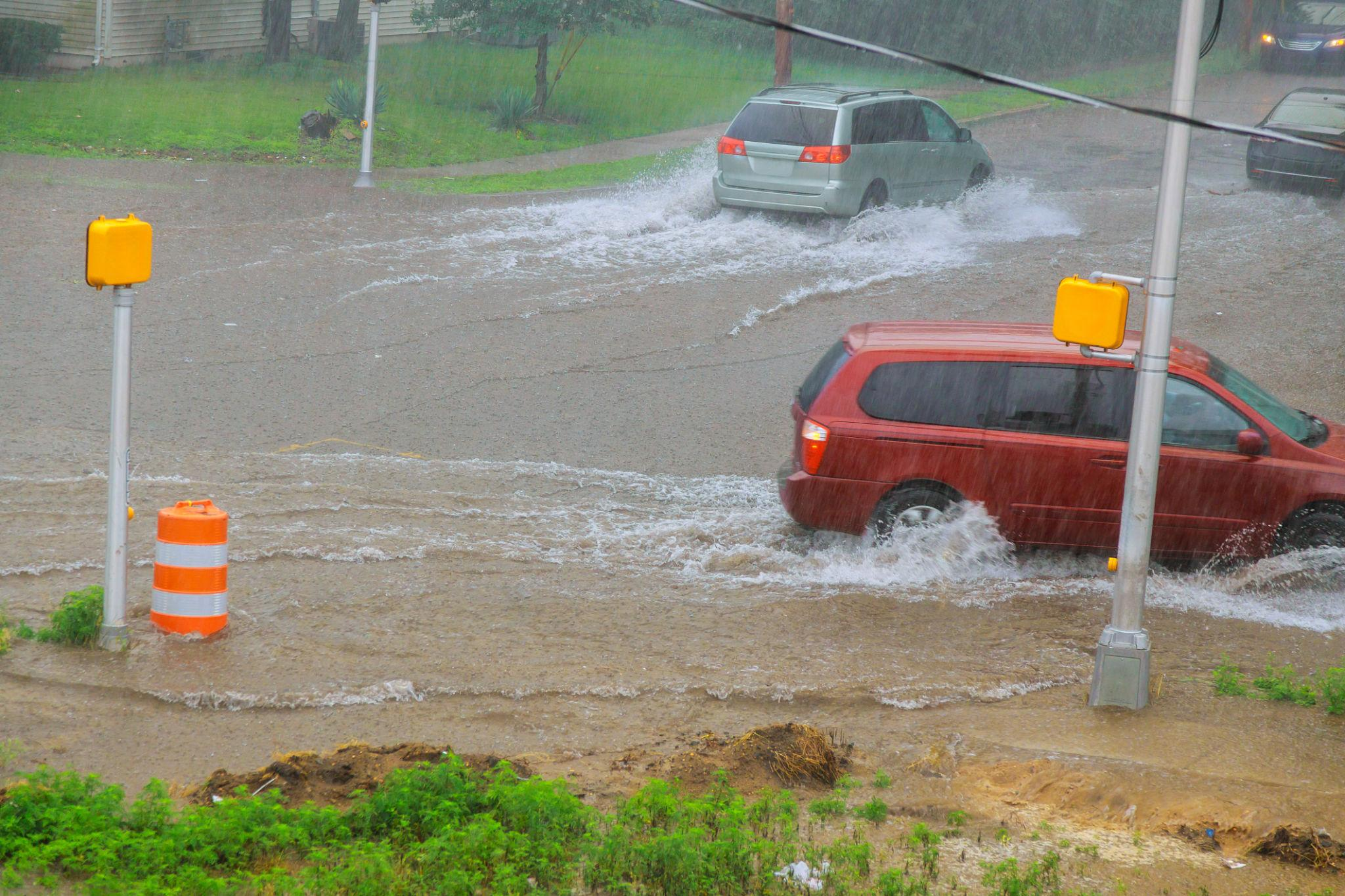
The Hidden Dangers of Flash Flooding
Flash floods are particularly dangerous because they strike quickly and often without warning. Key hazards include:
- Rapidly rising water levels
- Strong currents capable of sweeping vehicles away
- Reduced visibility during storms
- Submerged obstacles in roadways
In fact, many flood-related fatalities occur when people attempt to drive through flooded roads.
Local Impacts: What Communities Can Expect
Across Florida, the current weather setup is expected to produce:
- Scattered showers and thunderstorms throughout the day
- Heaviest rainfall in southern regions
- Localized flooding in urban areas
- Storm-related hazards such as gusty winds, lightning, and small hail
Areas south of the Caloosahatchee River are likely to see the highest rainfall totals, with additional accumulation on top of previous precipitation.
Even regions like Tampa Bay are seeing lingering moisture and additional rain chances following the cold front, reinforcing how widespread the conditions are.
The Bigger Picture: A Growing Global Concern
Flash flood risk is not limited to Florida. Around the world, similar patterns are emerging:
- Urban flooding is increasing due to climate change and heavier rainfall events
- Infrastructure in many cities is struggling to keep pace
- Rapid urbanization is amplifying vulnerability
Flooding is already the most common natural disaster, and flash floods are among the most unpredictable forms.
Looking Ahead: Why Preparedness Matters
As weather systems become more volatile, flash flood risk is expected to remain a persistent challenge. Forecasts like those in Florida highlight the importance of:
- Monitoring weather updates closely
- Avoiding flooded roads and low-lying areas
- Understanding local flood-prone zones
Even a “low-level” threat can produce dangerous conditions when rainfall is concentrated over short periods.
Conclusion: A Fast-Moving Hazard With Lasting Impact
Flash flood risk represents a complex balance between environmental need and immediate danger. While heavy rains can ease drought and reduce wildfire threats, they also introduce sudden and potentially life-threatening flooding.
The situation unfolding in Florida serves as a clear reminder: even moderate storms can escalate quickly under the right conditions. As climate patterns continue to shift, understanding and preparing for flash flood risk is becoming not just advisable—but essential.