Kansas City Weather Alert: Severe Storms, Tornado Risk, and Flooding Concerns
Key Highlights
- Severe thunderstorms are expected across Kansas City, driven by a strong cold front and humid conditions
- Main threats include damaging winds (up to 85 mph), large hail, and isolated tornadoes
- A 5–9% tornado probability has been identified within 25 miles of affected areas
- Flash flooding is a major concern, with rainfall rates reaching 1–3 inches per hour
- Peak storm activity is forecast between 2 p.m. and 7 p.m.
- Recent tornado outbreaks have already caused damage and injuries in surrounding regions
A Volatile Weather Pattern Unfolds Over Kansas City
Kansas City is facing a rapidly developing and potentially dangerous weather situation, as meteorologists track a volatile combination of atmospheric conditions. A cold front advancing from the northwest is colliding with a warm, moisture-rich air mass, creating an environment conducive to severe thunderstorms.
Temperatures have surged well above seasonal norms, climbing to around 83°F—significantly higher than the typical mid-April average. This excess heat, combined with humidity, is fueling instability in the atmosphere, setting the stage for intense storm development.
Forecasters indicate that thunderstorms could begin forming as early as mid-afternoon, quickly intensifying as they move across the region.
Breaking Down the Severe Threats
Damaging Winds and Large Hail Lead the Risks
The primary concerns for Kansas City residents are strong winds and hail. Meteorological projections show:
- Damaging winds: A 30–44% probability (rising to 45–59% southeast of the metro area) of winds reaching up to 75–85 mph
- Large hail: A similar 30–44% chance of hailstones measuring between 2 and 3.5 inches in diameter
These conditions can result in widespread property damage, including broken windows, damaged roofs, and downed trees.
Tornado Potential Cannot Be Ignored
While tornadoes are not considered the dominant threat, they remain a serious possibility. Forecast models estimate a 5–9% chance of a tornado forming within 25 miles of any given point, with potential intensity reaching up to EF3 strength.
Meteorologists emphasize that even a single tornado can have devastating consequences, particularly if storms develop independently ahead of the main frontal line.
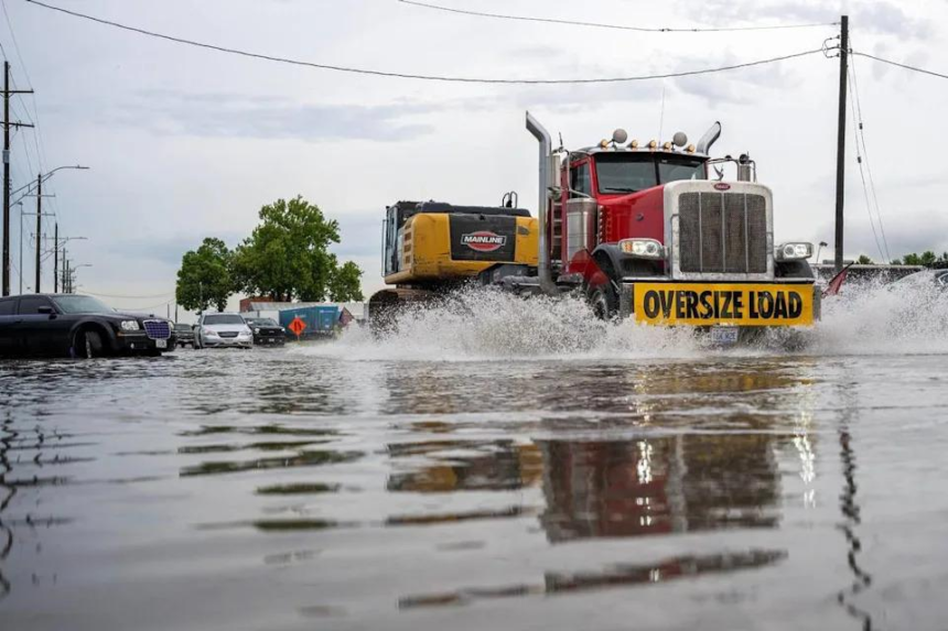
Flooding Emerges as a Critical Danger
Beyond wind and hail, flooding is emerging as one of the most significant risks in this weather event. Rainfall rates are expected to reach 1–3 inches per hour, with some localized areas potentially receiving 2–4 inches in a short period.
This raises the likelihood of flash flooding, especially in areas already saturated from recent rainfall.
Authorities stress a key safety message:
“Turn Around, Don’t Drown.”
Even relatively shallow moving water—just 6 to 12 inches—can carry away vehicles, including SUVs. Flooding consistently ranks among the deadliest weather hazards in the United States.
Timing: When Kansas City Will Be Most at Risk
The timeline for severe weather is relatively narrow but intense:
- Storm development: Between 1 p.m. and 4 p.m.
- Peak severity window: 2 p.m. to 7 p.m.
- Storm progression: Moving southeast through the evening
- Diminishing threat: Late evening into midnight
As storms evolve, they are expected to merge into clusters or lines, increasing the likelihood of damaging winds while slightly reducing—but not eliminating—the tornado risk.
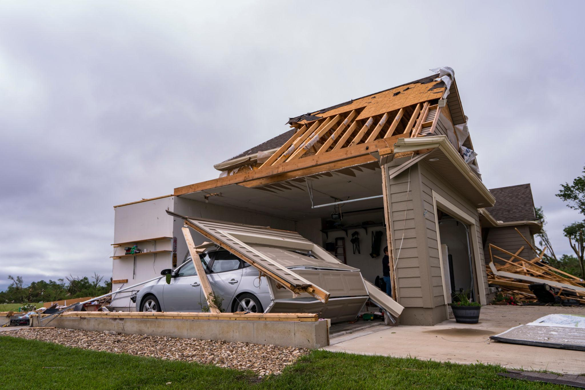
Recent Tornado Outbreak Raises Concern
This latest forecast comes on the heels of a recent and largely unexpected tornado outbreak in the region. Earlier in the week, at least five tornadoes touched down near Kansas City, causing injuries, damaging homes, and overturning vehicles.
The strongest of these tornadoes reached EF2 intensity, with wind speeds of approximately 125 mph.
What has drawn particular attention is how quickly the threat escalated. Forecast models initially underestimated the risk, only recognizing the severity shortly before the storms developed. This has sparked discussion within the meteorological community about forecasting challenges and data limitations.
Post-Storm Risks: Scams and Recovery Challenges
In the aftermath of severe weather, another threat often emerges—fraudulent contractors targeting storm victims.
Authorities and consumer protection agencies advise residents to take precautions when seeking repairs:
- Avoid signing contracts immediately with door-to-door contractors
- Request multiple estimates and verify credentials
- Never pay the full amount upfront
- Use staged payments tied to completed work
These measures are critical in preventing financial losses during recovery efforts.
What Comes Next: Cooler Weather and Stabilization
Once the storm system passes, Kansas City is expected to see a sharp drop in temperatures. Forecasts suggest:
- Highs falling to around 58°F over the weekend
- Overnight lows dipping into the 30s, with possible frost in rural areas
- A gradual rebound to the 70s early next week
This transition will bring calmer conditions, offering a temporary reprieve from the severe weather pattern.
Conclusion: A High-Impact Weather Event Demands Vigilance
The current Kansas City weather outlook reflects a high-impact, fast-evolving storm system with multiple hazards—damaging winds, large hail, isolated tornadoes, and flash flooding.
While not every area will experience the worst conditions, the combination of risks requires close monitoring and preparedness. The recent tornado activity underscores how quickly situations can escalate, even when initial forecasts suggest lower probabilities.
For residents, the priority is clear: stay informed, act quickly on warnings, and avoid unnecessary risks during peak storm hours.