Cyclone Vaianu: A Nation on Alert as a Powerful Storm Approaches
A Developing Weather Crisis in the Pacific
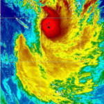
As April progresses, attention across New Zealand has sharply turned to a single, fast-developing weather system: Cyclone Vaianu. What began as a tropical disturbance has evolved into a large and potentially damaging cyclone now tracking toward the North Island, prompting widespread warnings, emergency preparations, and significant disruptions to daily life.
- A Developing Weather Crisis in the Pacific
- Escalating Warnings: From Watches to Red Alerts
- Local Impact: Communities Begin Immediate Preparations
- Infrastructure and Transport: Preparing for Disruption
- Agriculture and Economy: A Sector Under Pressure
- Public Safety Measures: A Nationwide Call to Prepare
- Behavioral Warnings: Avoiding Risk During the Storm
- Wider Disruptions: Events and Sporting Adjustments
- What Happens After: Recovery and Ongoing Risks
- A Defining Weather Event
- Conclusion: Preparedness as the First Line of Defense
Authorities, meteorologists, and local councils are increasingly aligned in their message—this is not a routine weather event. Instead, Cyclone Vaianu represents a high-impact system capable of bringing severe winds, heavy rainfall, and widespread disruption.
According to weather updates, the cyclone is expected to begin affecting regions from Sunday, with forecasts indicating escalating intensity as it approaches land.


Escalating Warnings: From Watches to Red Alerts
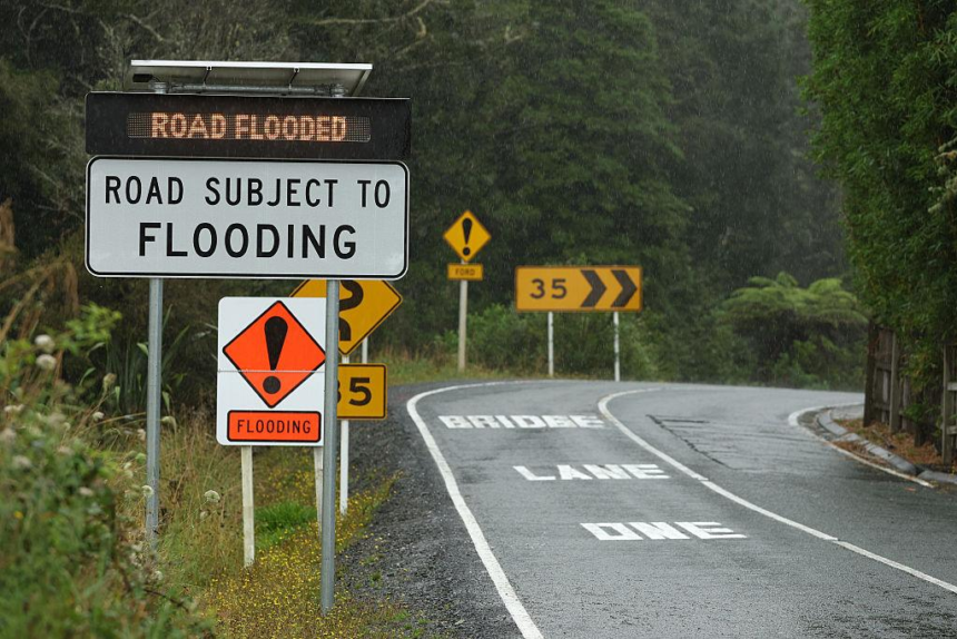
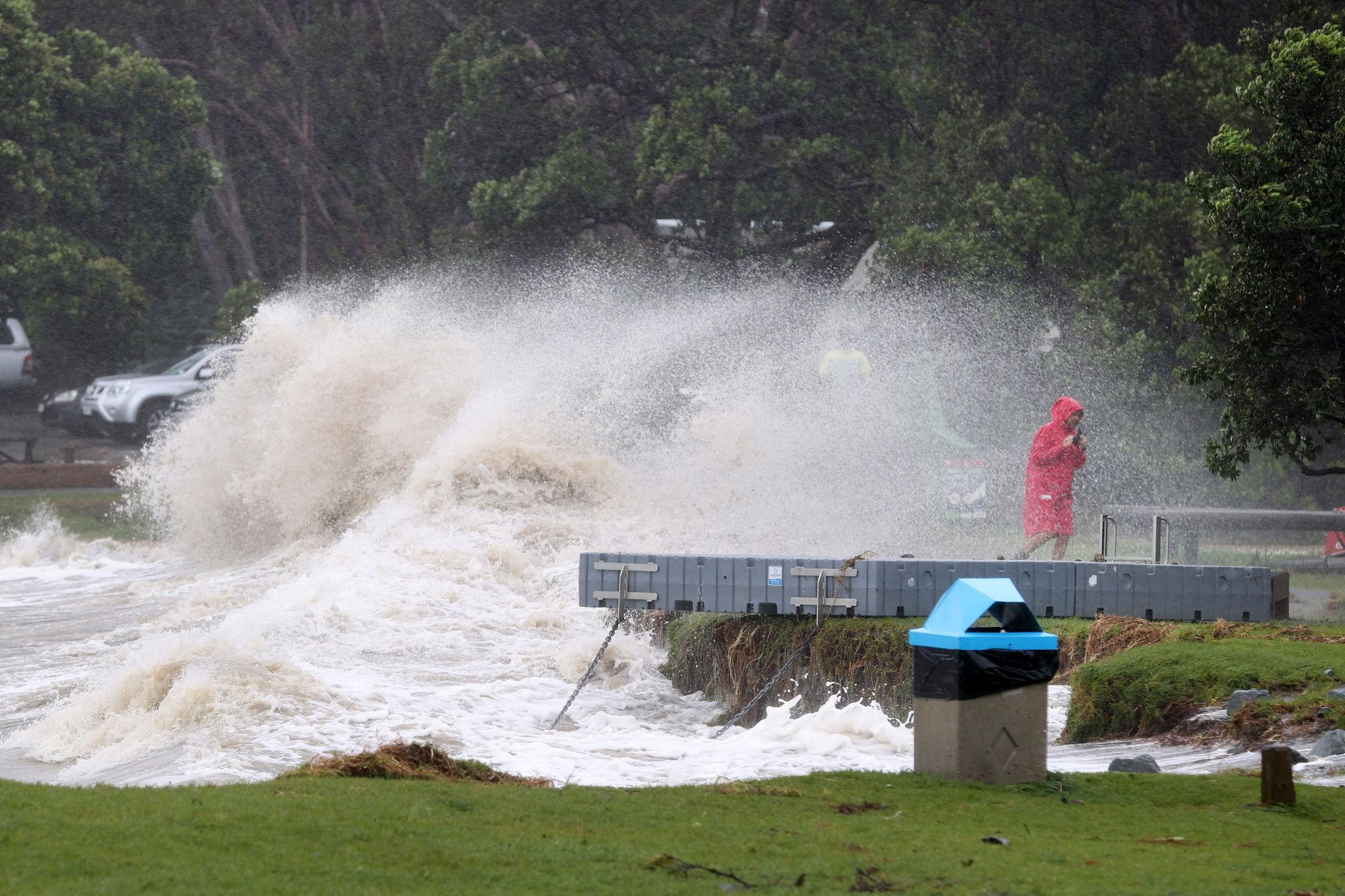
Meteorological agencies have issued a series of escalating warnings as confidence in the cyclone’s path and strength increases. A rare red wind warning has been declared for areas such as Aotea Great Barrier Island, signaling the likelihood of damaging gusts reaching up to 140 km/h.
Elsewhere, orange warnings and watches cover large parts of the North Island, indicating severe weather conditions including:


- Heavy rainfall accumulation of 70 to 100mm within hours
- Peak rainfall rates of 10 to 20mm per hour
- Gale-force winds capable of damaging infrastructure and vegetation
Meteorologists have also described the system as a “very large, damaging system”, emphasizing that even after some fluctuations in intensity, the cyclone retains significant destructive potential.
Local Impact: Communities Begin Immediate Preparations
At the local level, councils have begun implementing precautionary measures. In Rangitīkei, officials are closely monitoring the situation, with an Orange Wind Warning issued for northern areas and broader wind watches across the district.
The anticipated impact has already led to visible changes in community planning. Public events, including the Marton Harvest Festival scheduled for April 12, have been cancelled as a precaution to protect both people and property.
Authorities have also identified key vulnerabilities:


- Trees weakened by previous storms remain unstable
- Rural roads damaged in earlier weather events are still exposed
- Public parks and reserves face risks from falling debris
Council teams have been mobilized, with emergency staff on standby and essential supplies—such as generators and welfare kits—redeployed to rural communities to ensure readiness.
Infrastructure and Transport: Preparing for Disruption
Transport agencies are anticipating widespread disruption. The Auckland Transport Operations Centre has activated incident response teams to monitor real-time impacts across road and public transport networks.
Several risk factors are being actively managed:
- Flood-prone drainage areas are being cleared
- Construction sites are being secured
- Emergency maintenance crews are on standby
High-risk infrastructure, such as the Auckland Harbour Bridge, may face lane closures or full shutdowns if wind thresholds are exceeded.
Motorists have been advised to avoid unnecessary travel, particularly in conditions involving strong winds or flooding, where visibility and road stability may deteriorate rapidly.
Agriculture and Economy: A Sector Under Pressure
Beyond urban centers, the agricultural sector is watching Cyclone Vaianu with growing concern. In Tairāwhiti, the kiwifruit harvest is progressing well, with around six million trays already collected.
However, growers with fruit still on vines are now exposed to the cyclone’s potential impact. Strong winds and heavy rainfall could damage crops, delay harvesting, and disrupt supply chains.
This highlights a broader economic risk: severe weather events increasingly intersect with critical production periods, amplifying financial uncertainty for primary industries.
Public Safety Measures: A Nationwide Call to Prepare
Authorities have issued extensive guidance on how individuals and households should prepare. The objective is straightforward—reduce risk, ensure self-sufficiency, and avoid preventable emergencies.
Preparedness measures include:
- Securing outdoor items to prevent windborne debris
- Clearing gutters and drains to reduce flooding
- Assembling emergency kits with supplies for at least three days
- Charging electronic devices and preparing backup lighting
- Bringing pets indoors and relocating livestock if necessary
Officials stress that preparation is not optional. As one advisory notes, strong winds can turn unsecured objects into dangerous projectiles, posing risks to both property and life.
Behavioral Warnings: Avoiding Risk During the Storm
In addition to physical preparations, authorities are addressing behavioral risks. With school holidays and hunting season underway, many people may be inclined to travel or engage in outdoor activities.
However, emergency agencies are explicit: this is not the time for unnecessary movement.
Residents are urged to:
- Postpone travel plans where possible
- Avoid outdoor recreation during peak conditions
- Stay indoors once the storm arrives
- Monitor official updates from emergency services
The emphasis is clear—risk avoidance is as critical as physical preparation.
Wider Disruptions: Events and Sporting Adjustments
Cyclone Vaianu’s influence has already extended into the sporting calendar. A key international football fixture involving New Zealand’s Football Ferns has been rescheduled 24 hours earlier to avoid the cyclone’s arrival.
This decision, made collaboratively by multiple organizations, reflects the broader reality: the cyclone’s expected impact is significant enough to alter national schedules.
What Happens After: Recovery and Ongoing Risks
Even after the storm passes, risks will remain. Authorities caution that post-cyclone conditions can be equally hazardous due to:
- Floodwaters and unstable terrain
- Downed power lines
- Damaged buildings and infrastructure
Residents are advised to prioritize safety during cleanup, verify water quality before consumption, and document property damage for insurance purposes.
Emergency services also emphasize caution around damaged trees and electrical hazards, which may not be immediately visible.
A Defining Weather Event
Cyclone Vaianu is shaping up to be one of the more significant weather events of the season, not only because of its physical intensity but also due to its timing and geographic reach.
Its trajectory toward heavily populated and economically active regions places pressure on infrastructure, agriculture, and emergency systems simultaneously.
More importantly, it serves as a reminder of a broader trend: extreme weather events are becoming more frequent, more complex, and more disruptive.
Conclusion: Preparedness as the First Line of Defense
As Cyclone Vaianu approaches, the national response reflects a coordinated effort between meteorological agencies, local councils, emergency services, and communities.
The central message remains consistent—early preparation reduces risk.
While the full extent of the cyclone’s impact will only become clear in the coming days, one factor is already evident: preparedness, awareness, and timely action will determine how effectively communities withstand the storm.