Western Cape Weather Warning: Flood Risks Rise Across Eden and Central Karoo
South Africa is facing one of its most significant severe weather events of 2026 as the South African Weather Service (SAWS) issues multiple high-level warnings across the Western Cape, Eden District, Central Karoo, and parts of KwaZulu-Natal. Authorities say the combination of an intense cut-off low pressure system, heavy rainfall, gale-force winds, rough seas, and possible snowfall could trigger widespread flooding, infrastructure damage, transport disruptions, and dangerous travel conditions over several days.
The warnings have sparked growing concern across communities from the Garden Route to Durban, with disaster management teams, municipalities, schools, and emergency services placed on high alert.
The situation has become especially serious in the Garden Route and Eden District, where SAWS issued a rare Orange Level 8 warning — one of the highest alerts on the national weather warning scale.
Rare Orange Level 8 Warning Signals Major Threat
The South African Weather Service warned that disruptive rainfall would intensify from Wednesday, 6 May into Thursday, 7 May 2026, particularly across the eastern Garden Route. Officials described the expected conditions as potentially life-threatening.
Areas identified as highest risk include:
- Eastern Garden Route
- Eden District
- Central Karoo
- Kannaland
- Hessequa
- Coastal areas between Cape Agulhas and Plettenberg Bay
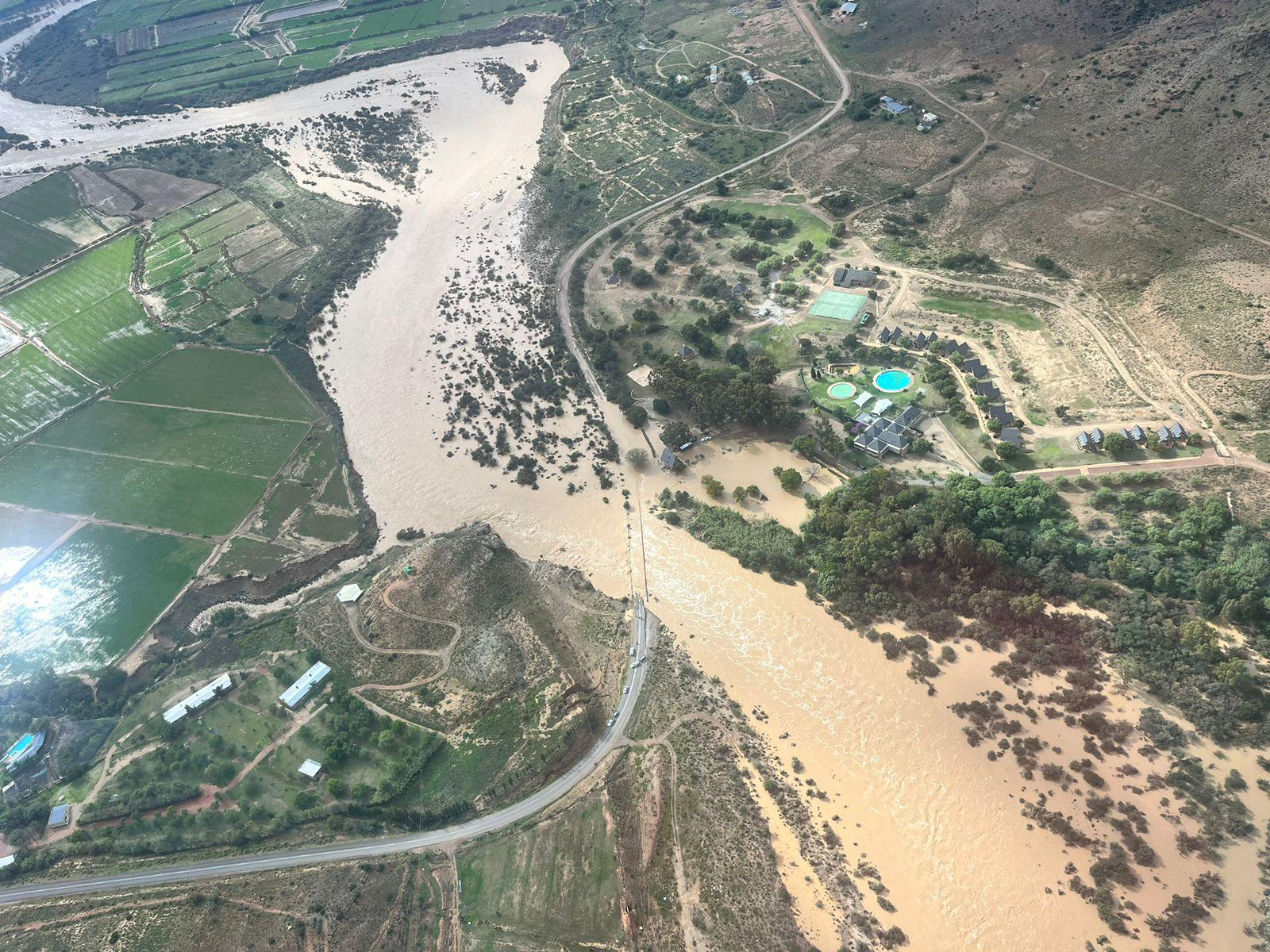
SAWS warned that rainfall totals in some parts of the Garden Route could reach between 150mm and 200mm.
Meteorologists explained that the intense cut-off low system is expected to produce prolonged periods of rain combined with powerful winds and unstable atmospheric conditions. This significantly increases the likelihood of:
- Flash flooding
- Mudslides
- Washed-away roads
- Flooded settlements
- Infrastructure collapse
- River overflow
- Coastal storm surges
The warning level reflects the seriousness of the expected impacts rather than just rainfall totals.
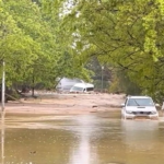
Eden District and Central Karoo Brace for Severe Flooding
Authorities in the Eden District and Central Karoo have activated emergency operations as conditions continue deteriorating. The Garden Route has emerged as one of the most vulnerable regions because of its mountainous terrain, flood-prone roads, and communities located near rivers and low-lying areas.
Officials warned that floodwaters could isolate communities, damage bridges, and interrupt essential services.
Several municipalities have already begun implementing emergency measures, including:
- Monitoring dams and rivers
- Preparing emergency shelters
- Coordinating rescue teams
- Distributing sandbags
- Closing dangerous roads
- Suspending transport services
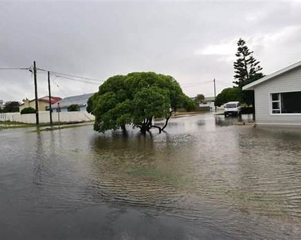
In George, authorities identified several high-risk flooding zones, including:
- CJ Langenhoven Street
- Wellington Street
- Cradock Street
- Hope Street
The Seven Passes Road was closed due to a sinkhole, while the Prince Alfred Pass between Uniondale and Knysna was shut because of flooding and rockfalls.
Meanwhile, all low-lying bridges in Oudtshoorn were reportedly closed because of dangerously high river flows.
Schools Shut as Storm Intensifies
As weather conditions worsened, education authorities in both the Western Cape and Eastern Cape moved quickly to close schools in high-risk districts.
The Western Cape Education Department confirmed temporary school closures across parts of:
- George
- Knysna
- Oudtshoorn
Learner transport services were also suspended due to dangerous road conditions and flood risks.
In the Eastern Cape, officials announced the closure of schools across Nelson Mandela Bay, Koukamma, Kouga, and Sundays River Valley municipalities.
Provincial education head Sharon Maasdorp urged parents and school communities to follow official weather advisories carefully as conditions evolved.
Some schools indicated they would reassess reopening decisions later in the week depending on rainfall intensity and road accessibility.
Coastal Areas Face Dangerous Seas and Gale-Force Winds
The severe weather system is not only affecting inland regions.
Along the southern coastline between Cape Agulhas and Plettenberg Bay, SAWS issued an Orange Level 6 warning for damaging winds and waves. Forecasters warned that sea swells could reach between 10 and 12 metres in some areas.
Authorities cautioned that the storm could lead to:
- Coastal erosion
- Harbour disruptions
- Dangerous maritime conditions
- Damage to beachfront infrastructure
- Risks to fishermen and small vessels
Emergency teams urged residents to stay away from beaches, rocky shorelines, and harbours during the peak of the storm.
Snowfall and Mudslide Risks Add to Concerns
While flooding remains the primary threat, weather officials also warned of possible disruptive snowfall over parts of the northeastern Central Karoo and high mountain passes.
Cold, wet, and windy conditions are expected to spread across southern Namakwa and central Western Cape regions.
Authorities also raised concern about mudslides in areas previously affected by wildfires during the summer season. Burned vegetation leaves slopes unstable, making them vulnerable to landslides during heavy rainfall.
KwaZulu-Natal Also Under Severe Weather Threat
The severe weather pattern is not limited to the Western Cape.
KwaZulu-Natal authorities warned that the N2 and N3 highways could face major disruptions as heavy rains spread across the province. The SA Weather Service issued Orange Level 6 and Yellow Level 4 warnings for parts of KZN.
Provincial disaster management teams activated a Joint Operations Centre to coordinate emergency responses.
Senzo Mzila, spokesperson for the Department of Cooperative Governance and Traditional Affairs (COGTA) in KwaZulu-Natal, said rainfall exceeding 80mm was expected in parts of the province.
The weather system could trigger:
- Flash flooding
- Lightning incidents
- Hailstorms
- Damaging winds
- Dangerous road conditions
“MEC for Cogta immediate priority is the protection of communities in low lying areas of settlements located near rivers and streams,” Mzila said.
Authorities confirmed that emergency teams would continue monitoring key transport routes and vulnerable settlements.
Why South Africa’s Weather Warnings Matter
South Africa’s weather warning system uses a colour-coded impact scale to communicate the severity of potential weather events.
An Orange Level 8 warning is among the highest alerts issued by SAWS and indicates a very high probability of severe disruption and danger to life.
Meteorologists say cut-off low pressure systems are particularly dangerous because they can remain stationary for long periods, producing prolonged heavy rainfall over the same areas.
This increases the risk of:
- River flooding
- Landslides
- Infrastructure collapse
- Prolonged power outages
- Human displacement
In recent years, South Africa has experienced several deadly flood disasters linked to similar weather systems, particularly in KwaZulu-Natal and parts of the Eastern Cape.
Emergency Services on Full Alert
Provincial disaster management centres, municipalities, emergency responders, and law enforcement agencies remain on standby across affected regions.
Authorities urged residents to:
- Avoid unnecessary travel
- Never cross flooded roads or bridges
- Stay updated through official SAWS alerts
- Secure loose outdoor objects
- Prepare emergency supplies
- Keep emergency contact numbers accessible
Community halls and temporary shelters may be activated in flood-prone areas if evacuations become necessary.
Officials warned that conditions could change rapidly depending on rainfall intensity and storm movement.
A Critical Test for South Africa’s Disaster Response Systems
The widespread weather warnings across the Western Cape, Eden District, Central Karoo, Durban, and other parts of South Africa highlight the growing pressure extreme weather events are placing on communities and emergency infrastructure.
With flooding risks increasing, transport routes threatened, and schools already closed in multiple districts, authorities face a major challenge in protecting lives and minimizing damage.
As the storm system continues moving across the country, millions of South Africans remain closely focused on SAWS updates and municipal emergency advisories.
The coming days may prove to be one of the most significant severe weather periods South Africa has experienced this year.