


Tropical Cyclone Narelle and the Red Sky Phenomenon: When Weather Turns Apocalyptic
A Sky That Stopped People in Their Tracks
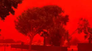
Residents across Western Australia witnessed a striking and unsettling transformation of the sky as Tropical Cyclone Narelle approached. Daylight dimmed, visibility dropped sharply, and a deep crimson hue spread across the horizon—turning ordinary landscapes into scenes that many described as surreal and even “apocalyptic.”
At Shark Bay Caravan Park in Denham, approximately 831km north of Perth, the atmosphere became heavy with dust. One observer described the moment vividly: “incredibly eerie outside,” noting that everything appeared coated in fine red particles. Despite the looming threat, winds had not yet peaked, prompting cautious hope that rainfall would eventually clear the air.
This unusual spectacle was not just visually dramatic—it was a direct result of a powerful meteorological chain of events tied to one of the most significant cyclones to traverse Australia in recent years.


The Journey of Tropical Cyclone Narelle
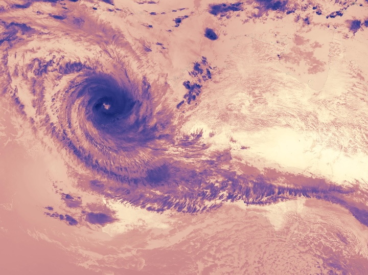
Tropical Cyclone Narelle was not a typical storm confined to a single region. Its path across Australia was both extensive and rare.
A Multi-State Impact
- The cyclone formed near the Solomon Islands, roughly 2,000km northeast of Australia
- It intensified and made landfall in Queensland on 20 March as a Category 4 tropical cyclone
- It continued westward across the Northern Territory
- It eventually reached Western Australia after traveling more than 5,700km
Such a trajectory is highly unusual. It is relatively rare for a single tropical cyclone to affect Queensland, the Northern Territory, and Western Australia in one continuous system. Comparable events have only been recorded a handful of times in modern meteorological history.


At its peak, Narelle’s destructive wind field extended 200 to 260 kilometers from its center, carrying immense energy across vast distances.
Why Did the Sky Turn Red?
The dramatic red sky was not caused by fire or pollution, but by a combination of dust physics and atmospheric optics.
The Role of Iron-Rich Soil
Western Australia’s interior contains large quantities of iron-rich soil. When Narelle’s strong winds swept across dry desert regions:
- Fine particles of red soil were lifted high into the atmosphere
- These particles contain iron oxide—essentially rust—which gives them their deep red color
- The dust spread over populated coastal areas, including Denham
Light Scattering and Color Shift
The red sky effect occurs due to how sunlight interacts with airborne particles:

- Shorter wavelengths of light (blue and violet) scatter more easily
- Longer wavelengths (red and orange) pass through the dust-filled air with less scattering
- As a result, the sky appears dominated by red tones
This is the same principle behind vivid sunsets—but in this case, the effect was intensified dramatically by the density of airborne dust.
A Rare Combination
Dust storms are not typically associated with tropical cyclones because such systems usually bring heavy rain. However, in this instance:
- The cyclone’s wind field passed over dry desert regions
- The lack of immediate rainfall allowed dust to accumulate rather than settle
- Strong winds effectively “scraped” particles from the ground and suspended them in the atmosphere
This combination of conditions made the event both visually striking and scientifically unusual.
Life Under a Crimson Sky
For residents, the red sky was more than a visual curiosity—it disrupted daily life.
Immediate Effects on Communities
- Visibility dropped to near zero in some areas
- Outdoor activity became unsafe or impractical
- Fine dust covered surfaces, homes, and vehicles
- Air quality deteriorated significantly
The environment felt oppressive and unfamiliar. The absence of strong winds at the time of observation added to the unease, as the visual intensity contrasted with an eerie stillness.
A Cyclone of Unusual Scale
Narelle’s defining feature was not only its visual impact but its geographic reach and intensity.
Key Characteristics
- Travel distance exceeding 5,700km
- Multi-region impact across three major Australian zones
- Category 4 strength at landfall
- Wind field extending up to 260km
This scale placed Narelle among the more remarkable tropical systems in recent Australian records.
Climate Context: Fewer Cyclones, Greater Intensity
Scientific observations indicate a broader trend affecting tropical cyclone behavior globally and regionally.
What the Data Shows
- Overall cyclone frequency in the Australian region has declined in recent decades
- However, cyclones are becoming more intense
- They are producing higher short-term and daily rainfall totals
- These trends are consistent with projections under ongoing global heating
In other words, while storms may occur less often, the ones that do form are increasingly powerful and capable of producing extreme conditions—such as the dust-driven red sky seen during Narelle.
Why This Event Matters
The red sky phenomenon associated with Tropical Cyclone Narelle highlights several critical insights:
1. Complex Weather Interactions
Cyclones are not limited to wind and rain—they can trigger secondary phenomena such as dust storms under the right conditions.
2. Expanding Impact Zones
The ability of a single cyclone to cross multiple states underscores the importance of coordinated national preparedness.
3. Climate Signals
Increasing intensity aligns with broader climate trends, raising concerns about future extreme weather events.
What Comes Next?
Looking ahead, events like Narelle may become more relevant in understanding how climate dynamics reshape weather systems.
Potential developments include:
- More frequent extreme weather combinations (e.g., cyclones plus dust storms)
- Greater unpredictability in cyclone paths and behavior
- Increased need for early warning systems and cross-regional coordination
- Heightened public awareness of atmospheric phenomena
Conclusion
The red skies over Western Australia were not just a dramatic visual anomaly—they were a direct manifestation of powerful atmospheric forces at work. Tropical Cyclone Narelle demonstrated how a single system can reshape environments, disrupt daily life, and reveal deeper patterns in Earth’s changing climate.
From its rare cross-country journey to its ability to turn the sky crimson, Narelle stands as a reminder that modern weather events are becoming more complex, more intense, and more impactful.