Greenland at a Turning Point: Ice, Sovereignty, Airports and Arctic Change
Greenland is often described through extremes: the world’s largest island, one of the planet’s most ice-covered places, a strategic Arctic territory, and a society balancing ancient cultural roots with fast-changing modern realities. But in 2026, Greenland is no longer only a remote symbol of climate change or geopolitical ambition. It is increasingly a place where several global stories meet at once: melting ice, Arctic security, tourism expansion, fisheries pressure, wildlife research, and democratic self-determination.
- The Ice Sheet That Shapes the World
- Why Satellite Monitoring Has Become Essential
- A New Gateway Opens in South Greenland
- Sovereignty Under Pressure
- Wildlife Science Beneath the Ice
- Fisheries and the Politics of Shared Seas
- Time, Identity and the Practical Details of Nationhood
- What Greenland’s Moment Means
Recent developments show Greenland moving through a decisive period. Satellite radar is tracking shifts in its ice sheet. A new airport in Qaqortoq is opening South Greenland to easier travel. Political leaders are rejecting outside pressure over the island’s future. Scientists are using drones to study bowhead whales under sea ice. Fisheries managers are setting quotas amid unresolved international disputes. Together, these developments reveal an island whose importance is expanding far beyond its small population and vast geography.
The Ice Sheet That Shapes the World
Greenland’s physical scale is difficult to overstate. It is the world’s largest island, and around 80% of its surface is covered by the Greenland Ice Sheet. That ice sheet is the second-largest ice mass on Earth after Antarctica’s and contains about 12% of the world’s glacier ice.

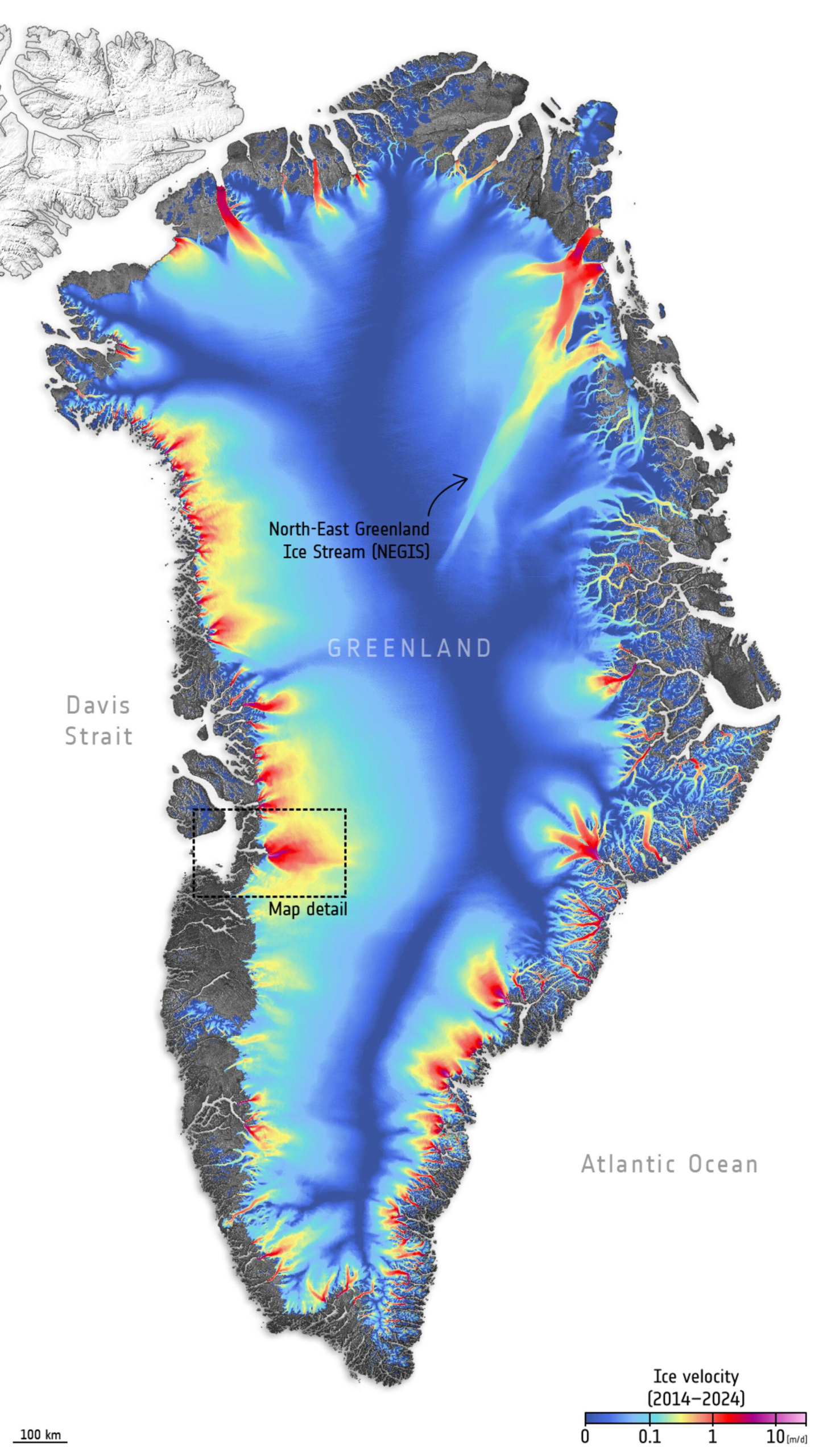
A recent Copernicus Sentinel-1 radar image of northeastern Greenland, captured through three acquisitions in January, February and March 2026, shows part of the island’s rugged, deeply indented coast. Radar images are usually not shown in colour, but in this case, each acquisition was assigned a different colour. When overlaid, the colours reveal surface changes between the three scans.
In the image, stable ice appears white, while grey areas show surfaces that have either not changed or changed very little. The most visible colour changes appear along the coast, where sea ice is constantly moving and shifting in type and cover.


The image also highlights three major outlet glaciers: 79N, also known as Nioghalvfjerdsfjorden; Zachariae Isstrøm; and Storstrømmen. These glaciers form the main front ends of the Northeast Greenland Ice Stream, a long ice stream connecting the interior of the ice sheet to the ocean. It drains approximately 12–17% of the Greenland Ice Sheet into the North Atlantic through these three glaciers.
That matters far beyond Greenland. The ice sheet’s continued melting is already contributing to rising seas, affecting low-lying coastal regions vulnerable to flooding and storm surges. If the Greenland Ice Sheet were to melt completely, global sea levels would rise by up to 7 metres, with catastrophic consequences for coastal societies worldwide.
Why Satellite Monitoring Has Become Essential
Greenland’s remoteness makes direct observation difficult. Much of the island is inaccessible, exposed to severe weather, and affected by long periods of darkness. This is where satellite missions such as Sentinel-1 become crucial.
The Sentinel-1 constellation images the entire Earth every six days. Each satellite carries an advanced radar instrument that can capture Earth’s surface through cloud and rain, day or night. For Greenland, that capability is particularly valuable because the most important changes often occur in places where field teams cannot easily work.


Sustained monitoring is not only about documenting ice loss. It also helps scientists improve climate models. Observations of Greenland runoff from space can be used to test how accurately models simulate ice sheet melting. Better models mean better predictions of how much Greenland may contribute to global sea-level rise in the future.
The stakes include ocean circulation as well. Increased freshwater entering the North Atlantic from Greenland’s melting ice could weaken the Gulf Stream, with potentially serious effects on northern Europe’s climate and wider atmospheric and oceanic systems.
A New Gateway Opens in South Greenland
While satellites monitor Greenland from above, major changes are also happening on the ground. South Greenland entered a new era of regional connectivity with the official opening of the new airport in Qaqortoq on 16 April 2026.
The airport replaces Narsarsuaq as the main air gateway to southern Greenland. Previously, visitors travelling to Qaqortoq often had to rely on helicopter transfers or long boat journeys, making access time-consuming and heavily dependent on weather.
The new facility has a 1,500-metre runway capable of handling Dash-8 Q200 and Q400 aircraft. It is expected to significantly reduce travel times into the region. Air Greenland plans year-round connections between Nuuk and Qaqortoq, while Icelandair is scheduled to begin seasonal summer flights from Keflavík, Iceland.
The opening ceremony was attended by Greenlandic officials, including Prime Minister Jens-Frederik Nielsen and Foreign Minister Múte Egede, who arrived on one of the inaugural flights from Nuuk. For Greenland, the airport is more than a transport project. It is part of a larger effort to modernize infrastructure and create economic opportunities outside the capital region.
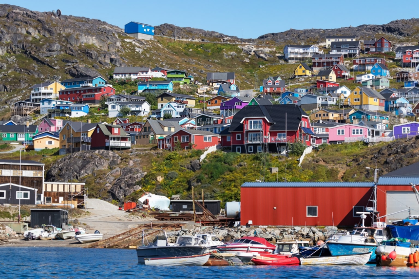
Qaqortoq, the largest town in South Greenland, is known for fjords, sheep farms, Norse archaeological sites and Inuit cultural heritage. Better access could expand tourism, support local businesses and create new opportunities in adventure travel and cultural experiences.
The airport is also part of a broader aviation expansion strategy. Following the development of Nuuk’s international airport, Ilulissat is expected to receive a new airport later in 2026. Together, these projects could reshape how people move across Greenland and how visitors experience the island.
Yet the benefits come with questions. Some discussions continue over the future of Narsarsuaq and how increased visitor numbers may affect smaller communities. Tourism can bring revenue, but in fragile Arctic settlements, growth must be managed carefully to avoid overwhelming local services, housing, culture and landscapes.
Sovereignty Under Pressure
Greenland’s strategic position has made it a focus of international attention, especially in relation to the United States, Denmark and Arctic security. That attention sharpened again after reports that an American individual had offered money to Greenlanders to sign a petition calling for the island to join the United States.
Greenland Prime Minister Jens-Frederik Nielsen strongly condemned the reported attempt. “A foreign individual is offering money for a signature to incorporate Greenland into another country. That is not just deeply worrying. It is indecent,” Nielsen wrote on Facebook.
Greenlandic broadcaster KNR reported that a “mysterious American” calling himself “Cliff” had offered a taxi driver in Nuuk $200,000 to sign the petition. The taxi driver, Danny Brandt, said he declined the offer and reported the incident to police. Another person reportedly commented that he had also been offered money to sign.
Greenland police said they had “received reports that cannot be ruled out as being connected to the current political situation,” though they did not confirm how many reports they had received or their “substance.”
Nielsen’s response framed the issue as a matter of democratic integrity. “We are a democratic society. Our future is not negotiated in a taxi. And it is not bought with money,” he said. “Decisions about our country are made by us. That ought to be easy enough to understand.”
The episode comes against a broader backdrop of renewed U.S. interest in Greenland. President Donald Trump has repeatedly said the United States needs to annex the Danish autonomous territory for national security reasons. In January, he backed down after several intense weeks of rhetoric, saying he had reached a “framework” agreement on Greenland with NATO’s secretary general, though the details remained vague.
Denmark and Greenland are now in talks with Washington about the future of the Arctic island. For Greenland, the central issue remains clear: outside powers may view the island through the lens of geography, minerals, defence and sea routes, but Greenlandic leaders insist its political future belongs to Greenlanders.
Wildlife Science Beneath the Ice
Greenland’s changing Arctic environment is also transforming the way scientists study wildlife. In Disko Bay in western Greenland, drone footage showed a bowhead whale breaking through about 24 inches, or 60 centimetres, of sea ice to breathe before slipping back under the frozen surface.
The scene was dramatic, but its scientific value goes beyond the moment itself. Bowhead whales are among the most ice-adapted large mammals on Earth. They can reach about 66 feet in length, and their bow-shaped skulls help them navigate a world where air holes may be scarce. Christiansen told Discover Wildlife that “This behavior happens frequently during the colder winter and spring months in Disko Bay,” when open water can be limited.
Drone research is becoming a powerful non-invasive tool for studying these animals. In Disko Bay, researchers used drone photogrammetry to estimate bowhead body size and condition by measuring body length, width and height from aerial images. The study reported 232 measurements from 154 adults and 50 measurements from 39 juveniles collected during spring fieldwork in 2022.
The data offer a window into whale health. Researchers estimated that adult body condition increased by 0.112 percentage points per day, equivalent to roughly 12 to 23 gallons of blubber gained per day for whales about 43 to 56 feet long. Using data from harvested whales, that blubber gain was estimated at about 82 to 163 pounds per day.
Those reserves matter because bowheads are “capital breeders,” meaning stored energy supports migration, growth and reproduction. Adult whales were estimated to need about 1,017 to 2,174 kilowatt-hours of energy per day, translating into roughly 225 to 481 pounds of prey per day, mainly zooplankton filtered through baleen. Juveniles were estimated to consume about 37 to 49 pounds per day.
The findings point to a deeper truth about Greenland’s Arctic ecology: even a whale’s breath through ice can become data. As sea ice changes, scientists are watching not only the ice itself but also the food webs and animal behaviours connected to it.
Fisheries and the Politics of Shared Seas
Greenland’s economy and food systems are also tied closely to the ocean. In 2026, Naalakkersuisut confirmed catch limits for mackerel and herring as international fisheries negotiations remained unresolved.
On 10 April 2026, Greenland set its mackerel quota at 19,435 tonnes and its herring quota at 25,000 tonnes. The mackerel quota may be fished in East Greenland waters and in the international zone, while the herring quota is restricted to East Greenland. The quotas were allocated to companies and vessels active in the fisheries during 2025.
The decision comes amid a continuing failure by Northeast Atlantic coastal states to reach a comprehensive agreement on sharing mackerel and herring stocks for 2026.
For mackerel, the International Council for the Exploration of the Sea recommended a total catch limit of 174,357 tonnes for 2026, a 71% reduction compared with 2025 advice. That recommendation reflected serious concern over the stock’s condition. But in the absence of a full coastal-state agreement, the United Kingdom, Norway, Iceland and the Faroe Islands agreed to a shallower 48% reduction from 2025 catch levels. Greenland chose to follow the same 48% reduction pathway.
The broader result is a fragmented management system. The coastal states fishing mackerel include the UK, Norway, the European Union, the Faroe Islands, Iceland and Greenland, with Russia also active in international waters. No unified quota-sharing arrangement has been agreed for 2026.
Based on decisions taken so far, the effective catch level implied by the 48% reduction framework corresponds to a total Northeast Atlantic mackerel catch of around 300,000 to 315,000 tonnes in 2026. Compared with the ICES-recommended ceiling of 174,357 tonnes, that would put overall catches roughly 70–80% above scientific advice before additional fishing pressure from Russia.
Herring is following a different path. ICES advised a total catch of 533,914 tonnes for 2026, a 32% increase compared with 2025, reflecting improved stock indicators. Even so, the lack of a long-term sharing agreement means the structural problem remains: without binding, science-based cooperation among all fishing nations, management of key pelagic stocks is likely to remain unstable into 2026 and 2027.
Time, Identity and the Practical Details of Nationhood
Some of Greenland’s changes are symbolic and practical at once. The Greenlandic government, Naalakkersuisut, supports abolishing daylight saving time. Government leader Jens-Frederik Nielsen confirmed plans to issue a new decree after a parliamentary majority expressed support for remaining permanently in the UTC-2 time zone. The change is expected to take effect on January 1, 2028, giving the public time to adjust.
On its own, a time-zone decision may seem administrative. But in Greenland’s wider context, it fits a pattern of practical self-definition. Airports, fisheries rules, climate monitoring, tourism planning and responses to foreign political pressure all speak to the same underlying question: how does Greenland shape its future on its own terms?
What Greenland’s Moment Means
Greenland is becoming more connected, more closely watched and more politically significant. Its ice sheet is a global climate indicator. Its waters are part of contested fisheries systems. Its wildlife offers clues about Arctic survival. Its airports could reshape tourism and regional economies. Its leaders are navigating external pressure while asserting democratic control over the island’s future.
The challenge is that each opportunity carries risk. More flights may bring jobs and visitors, but also pressure on small communities. More scientific attention can improve understanding, but it also highlights the speed of environmental change. More geopolitical interest can bring investment and security discussions, but it can also test the limits of sovereignty and public trust. Fisheries quotas can support livelihoods, but without international agreement they may intensify ecological strain.
Greenland’s importance in 2026 lies not only in what it is — a vast Arctic island covered largely by ice — but in what it represents. It is a frontline of climate change, a test of Arctic governance, a home to resilient communities, and a place where the future of the North Atlantic is being negotiated through science, infrastructure, politics and everyday life.
The world may look at Greenland for strategic reasons, environmental warnings or economic possibilities. But the clearest message from recent events is that Greenland is not a passive stage for global forces. It is an active society making choices about access, identity, resources and democracy — while the ice around it continues to change.