


Latest News on Cyclone Vaianu: North Island Braces for a High-Impact Storm
A Fast-Moving System Puts New Zealand on Alert
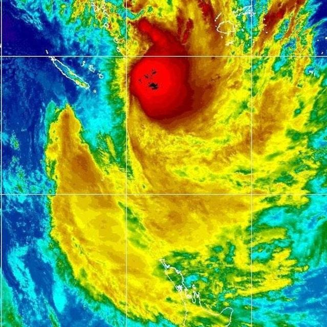
Cyclone Vaianu is rapidly emerging as one of the most closely watched weather systems affecting New Zealand in April 2026. As the storm tracks toward the upper North Island, authorities, meteorologists, and emergency services are escalating warnings, urging communities to prepare for what could become a “multi-hazard, potentially life-threatening” event.
- A Fast-Moving System Puts New Zealand on Alert
- State of Emergency Declared in Northland
- Severe Weather Warnings Intensify Across the North Island
- Auckland Prepares for Spillover Impacts
- A Multi-Hazard Threat: What Makes Vaianu Different
- Government and Emergency Services Mobilize
- Public Safety Guidance: Preparing for Impact
- Infrastructure and Transport Under Pressure
- A Region Already Under Strain
- What Happens Next: Monitoring an Uncertain Path
- Conclusion: A Critical Test of Preparedness
The cyclone’s trajectory and intensifying conditions have prompted a coordinated national response, with early emergency declarations, widespread weather alerts, and public safety advisories issued across affected regions.
State of Emergency Declared in Northland
The most significant development so far is the declaration of a State of Emergency across Northland, as officials anticipate the cyclone’s strongest impacts to hit the region first.

Authorities activated emergency powers as a precautionary measure, enabling rapid response actions such as evacuations, road closures, and access to private property if necessary to protect life and infrastructure.
Emergency management officials emphasized that the decision reflects uncertainty around the cyclone’s exact path and intensity, rather than confirmed worst-case outcomes. However, the risk profile remains high, particularly for eastern coastal areas expected to face severe winds and heavy rainfall.

Severe Weather Warnings Intensify Across the North Island
Meteorological agencies have issued multiple severe weather warnings, covering large parts of the North Island. Among these are rare and high-level alerts, including red wind warnings in exposed areas such as Aotea Great Barrier Island and the Coromandel Peninsula.
Forecasts indicate:
- Wind gusts reaching up to 140 km/h in exposed regions
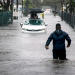
- Rainfall accumulation of 70–100 mm within 12 hours
- Widespread risks including flooding, landslides, and power outages
In addition, at least 18 weather watches and warnings have already been issued, reflecting the storm’s broad geographic impact and multi-layered hazards.
The severity of these warnings underscores the system’s complexity, combining strong winds, heavy rain, and coastal impacts into a single evolving threat.


Auckland Prepares for Spillover Impacts
While Northland is expected to bear the brunt of Cyclone Vaianu, Auckland is also preparing for significant disruption as the system moves south.
Authorities warn that the city could experience:
- Bursts of heavy rain
- Strong, potentially damaging winds
- Travel disruptions and public transport delays
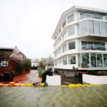
- Increased risk of localized flooding
Transport agencies have activated incident response teams to monitor real-time conditions and manage infrastructure risks, including bridge closures and road safety measures.
The Auckland Harbour Bridge, in particular, has been identified as a critical vulnerability, with the possibility of lane closures or full shutdowns if wind thresholds are exceeded.
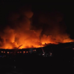
A Multi-Hazard Threat: What Makes Vaianu Different
Cyclone Vaianu is not being treated as a typical storm system. Meteorologists describe it as a “multi-hazard” event due to the convergence of several high-risk factors:
- Severe gale-force winds capable of structural damage
- Intense rainfall leading to flash flooding
- Coastal surges affecting low-lying communities
- Secondary risks such as falling trees, landslides, and infrastructure strain
This combination significantly increases the complexity of emergency response and heightens the potential for cascading impacts across transport, energy, and communication systems.
Government and Emergency Services Mobilize
National leadership has moved quickly to emphasize preparedness. Prime Minister Christopher Luxon has urged residents to take immediate action, advising people to “stock up, get supplies and tie things down.”
Emergency services, including Fire and Emergency New Zealand, are already scaling up readiness efforts, warning that the storm could be “fast-moving” and “high-intensity,” with widespread consequences.
At the same time, agencies continue to coordinate closely, holding ongoing meetings to assess evolving risks and deploy resources where needed.
Public Safety Guidance: Preparing for Impact
Authorities are strongly advising residents across the North Island to prepare proactively rather than reactively. The objective is to reduce risk exposure and ensure households can remain self-sufficient if services are disrupted.
Key Preparedness Measures
- Secure outdoor furniture and remove loose debris
- Clear drains and gutters to reduce flooding risk
- Charge devices and prepare backup power sources
- Assemble emergency supplies including food, water, and medical essentials
- Develop evacuation or contingency plans with family members
During the Storm
- Stay indoors and avoid unnecessary travel
- Monitor official updates through radio and emergency channels
- Avoid driving through floodwaters
- Unplug electrical appliances to prevent surge damage
Authorities also emphasize community responsibility, encouraging residents to check on vulnerable neighbors and support local preparedness efforts.
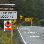
Infrastructure and Transport Under Pressure
The cyclone is expected to place considerable strain on infrastructure systems. Transport networks are particularly vulnerable, with potential impacts including:
- Road closures due to flooding or debris
- Disruptions to bus, rail, and ferry services
- Reduced visibility and hazardous driving conditions
- Increased accident risk during peak storm activity
Maintenance crews have been placed on standby, and monitoring systems are actively tracking potential hotspots for flooding and landslides.
A Region Already Under Strain
One of the more concerning aspects of Cyclone Vaianu is its timing. Several communities in the North Island are still recovering from recent severe weather events, compounding the potential impact.
Local officials have acknowledged the strain on residents, while also highlighting community resilience and preparedness efforts.
This context increases the urgency of current warnings, as repeated weather events can weaken infrastructure and reduce recovery capacity.
What Happens Next: Monitoring an Uncertain Path
Despite extensive forecasting, uncertainty remains around the cyclone’s precise track and intensity as it approaches land.
Meteorologists continue to monitor:
- Changes in wind strength and direction
- Rainfall distribution across regions
- Coastal impact zones
- Duration of severe weather conditions
Authorities stress that conditions could escalate quickly, reinforcing the need for ongoing vigilance and adherence to official guidance.
Conclusion: A Critical Test of Preparedness
Cyclone Vaianu represents a significant weather event with the potential to disrupt large parts of New Zealand’s North Island. The combination of early emergency declarations, high-level warnings, and coordinated national response highlights the seriousness of the situation.
While the full impact will depend on the cyclone’s final path, the current outlook suggests a challenging period ahead for communities, infrastructure, and emergency services.
The central message from authorities remains consistent: prepare early, stay informed, and prioritize safety as the storm approaches.