


Rainband Rain: How a Slow-Moving Weather System Is Bringing Heavy Rain, Storms and Flood Risk Across Australia
A slow-moving rainband has become the dominant weather feature across parts of Australia, drawing tropical moisture into the country’s interior and pushing widespread rain, thunderstorms and gusty winds from South Australia toward the eastern states.
- What Is Rainband Rain?
- South Australia Faces Heavy Rain and Flash Flooding Risk
- Adelaide and Eastern Districts Enter the Rain Zone
- Rainband Moves East Toward Victoria and Tasmania
- Warm Mornings Ahead of the Front
- Queensland, the Northern Territory and Tropical Moisture
- Western Australia Turns Cooler and Clearer
- Why Rainbands Can Be Dangerous
- What Comes Next?
- Conclusion: A Rainband With National Reach
The system is not simply a passing shower line. It is part of a broader weather pattern involving moisture-laden northwesterly winds, a low pressure system near the Bight, a cold front moving through the central states and a follow-up trough behind it. Together, these features are producing what forecasters describe as a vast band of cloud, rain and storms — the kind of setup capable of delivering useful rainfall in some areas while creating flash flooding risks in others.
On Wednesday, South Australia was at the centre of the developing event. By Thursday, the focus was expected to shift east, bringing a particularly wet day for Victoria and Tasmania while rain also extended into parts of northern Australia.


What Is Rainband Rain?
Rainband rain refers to rainfall produced by an elongated zone of cloud and precipitation. Unlike brief, isolated showers, a rainband can stretch across hundreds or even thousands of kilometres, bringing persistent rain, embedded thunderstorms and changing wind conditions as it moves.
In this case, the rainband has been fed by tropical moisture drawn southward by northwesterly winds. That moisture has interacted with a low pressure system passing over the Bight, creating a broad cloudband over South Australia. As the system continues eastward, it is being reinforced by a cold front and followed by a secondary trough, keeping showers and unsettled weather in the forecast even after the main rainband clears.


The result is a layered weather event: heavy rain and storms first, followed by cooler air, showers and blustery winds.
South Australia Faces Heavy Rain and Flash Flooding Risk
South Australia has been one of the first major impact zones. A northwest cloudband brought heavy rain and thunderstorms across parts of the state on Wednesday, with flash flooding possible in some areas.
The setup was driven by moisture-laden northwesterly winds interacting with a low pressure system passing over the Bight. This produced a vast band of cloud, rain and storms that spread across South Australia on Wednesday and into Thursday morning.
Some places had already recorded significant rainfall before the main system finished moving through. During the 24 hours ending at 9am on Wednesday, several areas in South Australia received close to 50 mm of rain. Tarcoola recorded 47 mm, making it the location’s heaviest June daily rainfall on record, with data available back to 1907.


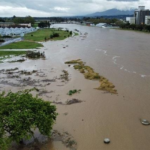
The heaviest rain on Wednesday was expected over South Australia’s North West Pastoral, West Coast and Eyre Peninsula districts. In these areas, six-hourly rainfall rates of 30 to 40 mm were possible, most likely during the morning and afternoon.
Those rainfall rates are important because heavy rain over a short period can overwhelm drainage systems, flood low-lying roads and create hazardous travel conditions, particularly where storms are embedded in the rainband.
Adelaide and Eastern Districts Enter the Rain Zone
After soaking western parts of South Australia, the rainband was forecast to spread across the state’s central and eastern districts between Wednesday afternoon and Thursday morning.
Adelaide was also expected to receive rain from the system, though totals were forecast to be lower than in the hardest-hit western and pastoral districts. The city could see around 10 to 20 mm from the main rainband.
By Thursday, the main rainband was expected to move out toward the eastern states during the morning. However, South Australia was not expected to return immediately to calm conditions. A follow-up low and trough were forecast to bring showers from the south-west coast toward the Eyre Peninsula and even Adelaide later in the day.
Thunderstorms were also possible, mainly near the coastal fringe. Adelaide was expected to have a cooler day, with a top of 15°C and the chance of a few showers.
Rainband Moves East Toward Victoria and Tasmania
As the system progressed, the national forecast highlighted Thursday, 18 June, as a particularly wet day for Victoria and Tasmania.
In Victoria, widespread rainfall was expected as the cold front moved through, starting in the west and pushing toward the east. Gippsland was expected to see more isolated rainfall compared with other parts of the state.
Winds were also expected to strengthen with the passage of the system. Damaging wind gusts of up to 100 km/h were forecast to develop about the alpine ranges in the evening. For Melbourne, the forecast called for a warm start of 15°C and an afternoon temperature of 19°C, with gusty conditions and a few possible showers.
Tasmania was also expected to see rainfall increase as the cold front approached through the day. In a humid air mass and warmer-than-average northerly flow, rain was forecast to increase especially across the north and west. Showers were expected to be more isolated through southern and eastern parts of the island.
Hobart was forecast to reach 18°C with possible showers.
Warm Mornings Ahead of the Front
One of the striking features of this weather pattern is the contrast between warm air ahead of the front and cooler conditions behind it.
Ahead of the frontal system, warm northerly winds were expected to continue across the south-east, bringing the possibility of record warm June mornings in some inland areas.
New South Wales was forecast to have a warm start, with possible record warm June mornings through inland parts. Rain was expected to increase from the far west and across the southern plains before gradually moving farther east through the day. However, areas east of the main ranges were expected to remain dry and warm or mild.
Sydney was forecast to reach 23°C, marking the 12th day in a row above 20°C. Canberra was expected to start at 7°C and warm to 17°C, with possible later showers.
The warm morning pattern shows how rainband systems often arrive with a strong flow of mild, moist air before a cooler change moves in.
Queensland, the Northern Territory and Tropical Moisture
The rainband was not confined to southern Australia. Forecast guidance also pointed to rain extending into northern Australia.
In Queensland, patches of morning fog were expected through inland parts of the east. Wet weather was forecast to develop as the rainband moved in from the south-west, bringing rain and storms to areas south-west of about Mount Isa in the north and through to around Cunnamulla in the south. Along the east coast, isolated showers were expected to continue, becoming a little more scattered farther north.
Brisbane was forecast to reach 23°C with a partly cloudy day.
In the Northern Territory, forecasters noted that the system was beginning to tap into tropical moisture as the rainband moved through. Rainfall totals of up to 20 mm were possible through central and southern parts. Farther north, showers were still possible, though generally lighter.
Darwin was forecast to reach 31°C with the chance of a light shower. Farther south, in the lee of the trough, cooler temperatures were expected. Alice Springs was forecast to reach only 20°C with shower activity.
Western Australia Turns Cooler and Clearer
While the central and eastern parts of the country dealt with the moving rainband, Western Australia was under a different influence.
A high-pressure ridge in the west was expected to bring cool and clear conditions. Southerly flow was forecast to continue producing isolated shower or drizzle activity, extending somewhat inland through the south-east. Elsewhere, conditions were expected to be generally dry and settled.
Perth was forecast to start at 5°C and reach just 17°C. Inland areas were expected to experience another cool morning, with areas of fog and frost.
This contrast highlights the national scale of the weather pattern: unsettled and moisture-rich conditions moving east, while cooler, clearer weather builds behind the system in the west.
Why Rainbands Can Be Dangerous
Rainbands are sometimes perceived as ordinary wet-weather features, but they can become hazardous when several ingredients align.
In this event, the key risk factors include:
Persistent moisture feeding into the system, allowing rain to continue over several hours.
Embedded thunderstorms, which can sharply increase local rainfall intensity.
Low pressure and frontal dynamics, which help lift moist air and generate widespread cloud and rain.
Strong winds behind or near the system, especially as troughs and fronts move through.
In South Australia, six-hourly rainfall rates of 30 to 40 mm were possible in some districts. That kind of rainfall can quickly create flash flooding, especially in dry landscapes where heavy rain runs off hard ground before soaking in.
The follow-up threat is wind. Even after the main rainband clears, another round of showers and blustery winds was expected as the low passed south of South Australia. Damaging winds were possible in some areas on Thursday, most likely along the West Coast.
What Comes Next?
The main rainband was forecast to clear from South Australia on Thursday morning, but the broader unsettled pattern was expected to continue across parts of the country.
For South Australia, the immediate concern shifts from the main rainband to showers, thunderstorms near coastal areas and possible damaging winds. For Victoria and Tasmania, Thursday becomes the wetter focus as the cold front advances. For New South Wales and Queensland, rain is expected to expand from inland and south-western areas, while some coastal regions remain comparatively drier.
The system also demonstrates how Australian rain events can connect distant air masses: tropical moisture from the north, a low near the Bight, a cold front crossing the central states and a trailing trough all working together to produce a broad zone of rain.
Conclusion: A Rainband With National Reach
The current rainband rain event is a reminder that major weather impacts do not always come from a single storm cell. Sometimes the bigger concern is a slow-moving, moisture-rich system that spreads rain across multiple states, raises flood risk in vulnerable districts and changes the temperature and wind pattern across the country.
For South Australia, the event has already delivered notable rainfall, including Tarcoola’s heaviest June daily rainfall on record. For Victoria and Tasmania, the system points to a wet and windy Thursday. For northern and eastern Australia, the rainband’s reach shows how tropical moisture can feed into broader national weather systems.
As the rainband continues east and secondary troughs follow behind, communities across affected regions will need to remain alert to changing conditions, especially where heavy rain, thunderstorms and damaging winds overlap.


